Fitxer:Minustah.png
Minustah.png (603 × 449 píxels, mida del fitxer: 181 Ko, tipus MIME: image/png)
| Aquest fitxer i la informació mostrada a continuació provenen del dipòsit multimèdia lliure Wikimedia Commons. |
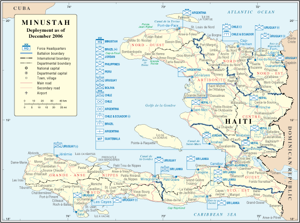
| Descripció | Map of Haiti | |||
| Data | ||||
| Font | http://www.un.org/Depts/Cartographic/map/dpko/minustah.pdf | |||
| Autor | Department of Peacekeeping Operations Cartographic Section | |||
| Permís (Com reutilitzar aquest fitxer) |
|

Historial del fitxer
Cliqueu una data/hora per veure el fitxer tal com era aleshores.
| Data/hora | Miniatura | Dimensions | Usuari/a | Comentari | |
|---|---|---|---|---|---|
| actual | 04:01, 23 oct 2007 | | 603 × 449 (181 Ko) | Jeroen | Bottom line is allowed according permissions by the UN: "UN maps are open source material and you can use them in your work or for making your own map. We request however that you '''delete the UN name and reference number upon any modification''' to the |
| 01:17, 23 gen 2007 |  | 609 × 466 (181 Ko) | Cro-Cop2 | {{Information| |Description=Map of Haiti |Source=http://www.un.org/Depts/Cartographic/map/dpko/minustah.pdf |Date=December, 2006 |Author=Department of Peacekeeping Operations Cartographic Section |Permission={{UN map}} }} |
Ús del fitxer
Les 2 pàgines següents utilitzen aquest fitxer:
Ús global del fitxer
Utilització d'aquest fitxer en altres wikis:
- Utilització a bg.wikipedia.org
- Utilització a ckb.wikipedia.org
- Utilització a de.wikipedia.org
- Utilització a en.wikipedia.org
- Utilització a en.wikinews.org
- Utilització a es.wikipedia.org
- Utilització a fa.wikipedia.org
- Utilització a fr.wikipedia.org
- Utilització a ht.wikipedia.org
- Utilització a id.wikipedia.org
- Utilització a mzn.wikipedia.org
- Utilització a nl.wikipedia.org
- Utilització a ru.wikipedia.org
- Utilització a www.wikidata.org