Fitxer:Mont Blanc massif (east).jpg

Mida d'aquesta previsualització: 800 × 600 píxels. Altres resolucions: 320 × 240 píxels | 640 × 480 píxels | 1.024 × 768 píxels | 1.280 × 960 píxels | 2.560 × 1.920 píxels | 3.000 × 2.250 píxels.
Fitxer original (3.000 × 2.250 píxels, mida del fitxer: 395 Ko, tipus MIME: image/jpeg)
| Aquest fitxer i la informació mostrada a continuació provenen del dipòsit multimèdia lliure Wikimedia Commons. |
.jpg?uselang=ca)
Resum
| Descripció |
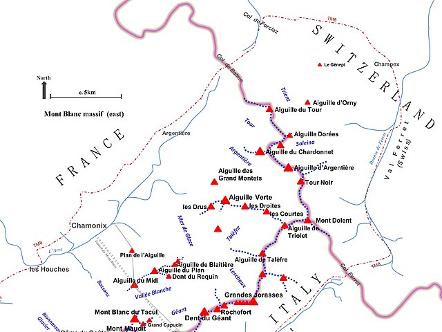
English: Main summits and ridges of the eastern half of the Mont Blanc massif.
The general position and direction of flow of some major glaciers and main rivers, plus the approximate route of the Tour du Mont Blanc (TMB), the Tunnel du Mont Blanc and the aerial cableway between Chamonix and Courmayeur, are also indicated. Boundary between France, Italy and Switzerland is shown in grey. |
| Data | |
| Font | Treball propi |
| Autor | Nick_Moyes |
| Permís (Com reutilitzar aquest fitxer) |
© OpenStreetMap contributors |
All features are indicative, based on rough tracing or comparison against OpenStreet Maps (© OpenStreetMap contributors) and to Wikimedia File: Chamonix and Mont-Blanc map 1892.jpg. Occasional reference to Bing aerial imagery for final error-checking.
Llicència
Jo, el titular dels drets d'autor d'aquest treball, el public sota la següent llicència:
This file is licensed under the Creative Commons Attribution-Share Alike 4.0 International license.
- Sou lliure de:
- compartir – copiar, distribuir i comunicar públicament l'obra
- adaptar – fer-ne obres derivades
- Amb les condicions següents:
- reconeixement – Heu de donar la informació adequada sobre l'autor, proporcionar un enllaç a la llicència i indicar si s'han realitzat canvis. Podeu fer-ho amb qualsevol mitjà raonable, però de cap manera no suggereixi que l'autor us dóna suport o aprova l'ús que en feu.
- compartir igual – Si modifiqueu, transformeu, o generareu amb el material, haureu de distribuir les vostres contribucions sota una llicència similar o una de compatible com l'original
Historial del fitxer
Cliqueu una data/hora per veure el fitxer tal com era aleshores.
| Data/hora | Miniatura | Dimensions | Usuari/a | Comentari | |
|---|---|---|---|---|---|
| actual | 22:23, 21 maig 2016 | | 3.000 × 2.250 (395 Ko) | Nick Moyes | enhanced version with countries added |
| 15:46, 12 gen 2016 |  | 3.000 × 2.250 (378 Ko) | Nick Moyes | User created page with UploadWizard |
Ús del fitxer
La pàgina següent utilitza aquest fitxer:
Ús global del fitxer
Utilització d'aquest fitxer en altres wikis:
- Utilització a cs.wikipedia.org
- Utilització a en.wikipedia.org
- Utilització a uk.wikipedia.org
.jpg)