Fitxer:Morrison Formation Brachiosauridae map.png

Mida d'aquesta previsualització: 627 × 600 píxels. Altres resolucions: 251 × 240 píxels | 502 × 480 píxels | 803 × 768 píxels | 1.071 × 1.024 píxels | 2.540 × 2.429 píxels.
Fitxer original (2.540 × 2.429 píxels, mida del fitxer: 73 Ko, tipus MIME: image/png)
| Aquest fitxer i la informació mostrada a continuació provenen del dipòsit multimèdia lliure Wikimedia Commons. |
Resum
| Descripció |
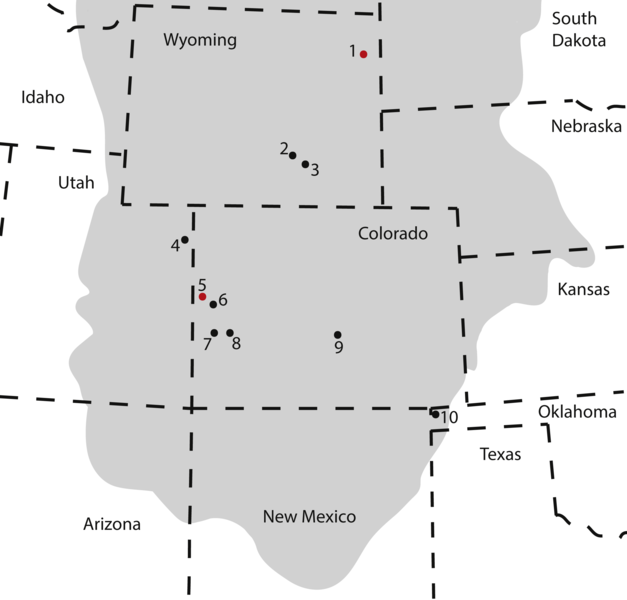
Map of occurrences of Brachiosauridae in the Upper Jurassic Morrison Formation. The locality of the pes described herein (1) and the type locality of Brachiosaurus altithorax (5) are highlighted in red. The gray area indicates the distribution of the Morrison Formation. 1, Bobcat Pit, Weston County, WY; 2, Freezeout Hills general, Carbon Co., WY; 3, Reed’s Quarry 13, Albany Co., WY; 4, Jensen/Jensen Quarry, Uintah Co., UT; 5, Fruita Paleontological Area general, Mesa Co., CO; 6, Riggs Quarry 13, Mesa Co., CO; 7, Dry Mesa Quarry, Mesa Co., CO; 8, Potter Creek Quarry, Montrose Co., CO; 9, Felch Quarry 1, Fremont Co., CO; 10, Kenton Pit 1, Cimarron Co., OK. Modified from Bonnan & Wedel (2004: fig. 2). |
| Data | |
| Font | https://peerj.com/articles/5250/ |
| Autor | Anthony Maltese, Emanuel Tschopp, Femke Holwerda, David Burnham |
| Permís (Com reutilitzar aquest fitxer) |
https://peerj.com/articles/5250.pdf |
Llicència
This file is licensed under the Creative Commons Attribution 4.0 International license.
- Sou lliure de:
- compartir – copiar, distribuir i comunicar públicament l'obra
- adaptar – fer-ne obres derivades
- Amb les condicions següents:
- reconeixement – Heu de donar la informació adequada sobre l'autor, proporcionar un enllaç a la llicència i indicar si s'han realitzat canvis. Podeu fer-ho amb qualsevol mitjà raonable, però de cap manera no suggereixi que l'autor us dóna suport o aprova l'ús que en feu.
Aquest fitxer, que originalment va ser publicat en https://peerj.com/articles/5250/, va ser revisat 24 July 2018 pel revisor Guanaco, qui va confirmar que estava disponible allà sota la llicència establerta en aquesta data.
|
Historial del fitxer
Cliqueu una data/hora per veure el fitxer tal com era aleshores.
| Data/hora | Miniatura | Dimensions | Usuari/a | Comentari | |
|---|---|---|---|---|---|
| actual | 19:09, 10 ago 2018 | | 2.540 × 2.429 (73 Ko) | HerrAdams | Cropped 1 % horizontally, 1 % vertically using CropTool with precise mode. Removed border. |
| 22:17, 24 jul 2018 |  | 2.571 × 2.460 (111 Ko) | FunkMonk | == {{int:filedesc}} == {{Information |description=Map of occurrences of Brachiosauridae in the Upper Jurassic Morrison Formation. The locality of the pes described herein (1) and the type locality of Brachiosaurus altithorax (5) are highlighted in red. The gray area indicates the distribution of the Morrison Formation. 1, Bobcat Pit, Weston County, WY; 2, Freezeout Hills general, Carbon Co., WY; 3, Reed’s Quarry 13, Albany Co., WY; 4, Jensen/Jensen Quarry, Uintah Co., UT; 5, Fruita Paleontolo... |
Ús del fitxer
La pàgina següent utilitza aquest fitxer:
Ús global del fitxer
Utilització d'aquest fitxer en altres wikis:
- Utilització a ar.wikipedia.org
- Utilització a ast.wikipedia.org
- Utilització a bg.wikipedia.org
- Utilització a cs.wikipedia.org
- Utilització a en.wikipedia.org
- Utilització a eu.wikipedia.org
- Utilització a he.wikipedia.org
- Utilització a hr.wikipedia.org
- Utilització a hu.wikipedia.org
- Utilització a mk.wikipedia.org
- Utilització a nn.wikipedia.org
- Utilització a pl.wikipedia.org
- Utilització a sv.wikipedia.org
- Utilització a tr.wikipedia.org
- Utilització a www.wikidata.org
- Utilització a zh.wikipedia.org