Fitxer:Moskau1941vonLuckJackroma.jpg
Mida d'aquesta previsualització: 436 × 600 píxels. Altres resolucions: 174 × 240 píxels | 349 × 480 píxels | 558 × 768 píxels | 744 × 1.024 píxels | 2.550 × 3.509 píxels.
Fitxer original (2.550 × 3.509 píxels, mida del fitxer: 9,38 Mo, tipus MIME: image/jpeg)
| Aquest fitxer i la informació mostrada a continuació provenen del dipòsit multimèdia lliure Wikimedia Commons. |
Resum
| Descripció |
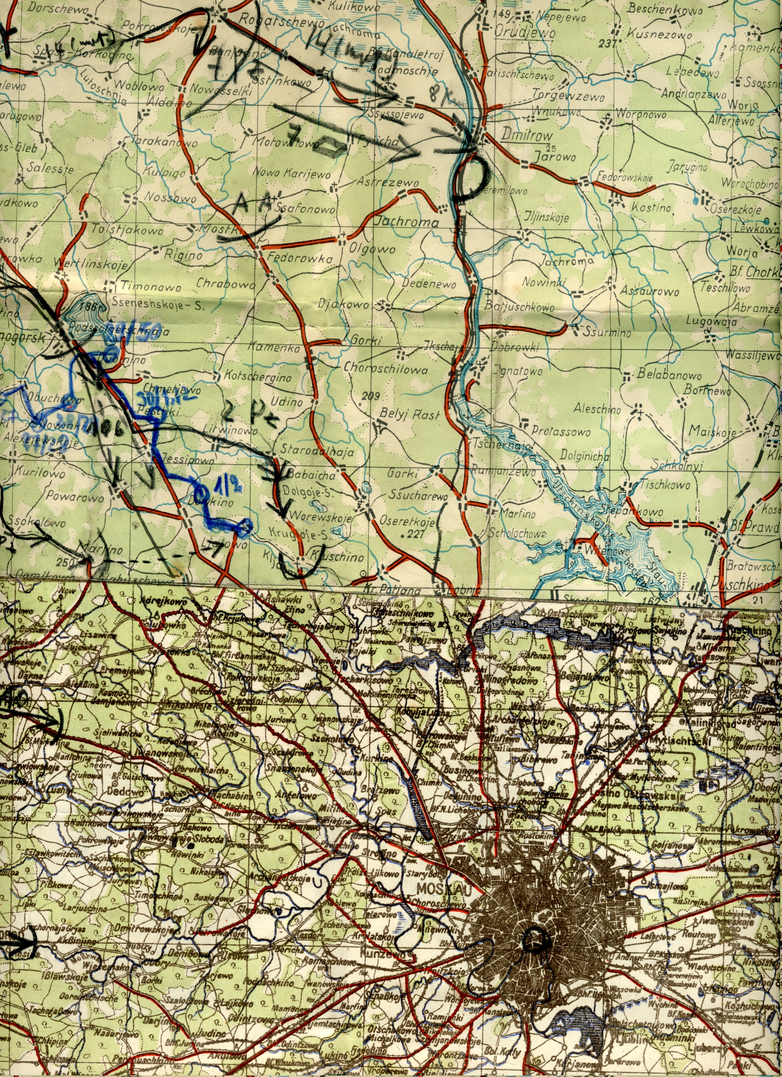
English: This is the map Hans von Luck used during the advance on Moscow [Moskau] during
World War Two WWII [WK2]. It details the limit of his advance to a small village called Jachroma. Von Luck gives an account of this advance in his memoirs "Panzer Commander". The maps shows the furthest advance of the German Army [Heer] toward Moscow. The map was constructed from several German maps which were joined together. |
| Data | |
| Font | Treball propi |
| Autor | ArminWenger |
Llicència
| Jo, el titular del copyright d'aquesta obra, l'allibero al domini públic. Això s'aplica a tot el món. En alguns països això pot no ser legalment possible, en tal cas: Jo faig concessió a tothom del dret d'usar aquesta obra per a qualsevol propòsit, sense cap condició llevat d'aquelles requerides per la llei. |
Historial del fitxer
Cliqueu una data/hora per veure el fitxer tal com era aleshores.
| Data/hora | Miniatura | Dimensions | Usuari/a | Comentari | |
|---|---|---|---|---|---|
| actual | 15:24, 1 feb 2009 | | 2.550 × 3.509 (9,38 Mo) | ArminWenger | {{Information |Description={{en|1= This is the map Hans von Luck used during the advance on Moscow [Moskau] during World War Two WWII [WK2]. It details the limit of his advance to a small village called Jachroma. Von Luck gives an account of this adv |
Ús del fitxer
La pàgina següent utilitza aquest fitxer:
Ús global del fitxer
Utilització d'aquest fitxer en altres wikis:
- Utilització a ar.wikipedia.org
- Utilització a en.wikipedia.org
- Utilització a es.wikipedia.org
- Utilització a fi.wikipedia.org
- Utilització a ja.wikipedia.org
- Utilització a pt.wikipedia.org
- Utilització a tr.wikipedia.org
- Utilització a zh.wikipedia.org