Fitxer:MountGriggs.jpg

Mida d'aquesta previsualització: 800 × 538 píxels. Altres resolucions: 320 × 215 píxels | 640 × 430 píxels | 1.024 × 688 píxels.
Fitxer original (1.024 × 688 píxels, mida del fitxer: 180 Ko, tipus MIME: image/jpeg)
| Aquest fitxer i la informació mostrada a continuació provenen del dipòsit multimèdia lliure Wikimedia Commons. |
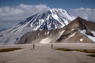
| Descripció | Mount Griggs volcano, 2,317-m (7,602 ft)-high, here seen from the west rim of Katmai caldera, lies 10 km (6 mi) behind the volcanic arc defined by other Katmai group volcanoes. Although no historic eruptions have been reported from Mount Griggs, vigorously active fumaroles persist in a summit crater and along the upper southwest flank. The slopes of Mount Griggs are heavily mantled by fallout from the 1912 eruption of Novarupta volcano. View is to the northwest. | |||
| Data | ||||
| Font | http://pubs.usgs.gov/dds/dds-40/ | |||
| Autor | R. McGimsey, U.S. Geological Survey | |||
| Permís (Com reutilitzar aquest fitxer) |
|
Historial del fitxer
Cliqueu una data/hora per veure el fitxer tal com era aleshores.
| Data/hora | Miniatura | Dimensions | Usuari/a | Comentari | |
|---|---|---|---|---|---|
| actual | 15:25, 20 gen 2005 | | 1.024 × 688 (180 Ko) | GarciaB~commonswiki | Mount Griggs Volcano, Alaska |
Ús del fitxer
La pàgina següent utilitza aquest fitxer:
Ús global del fitxer
Utilització d'aquest fitxer en altres wikis:
- Utilització a arz.wikipedia.org
- Utilització a ceb.wikipedia.org
- Utilització a de.wikipedia.org
- Utilització a en.wikipedia.org
- Utilització a es.wikipedia.org
- Utilització a fr.wikipedia.org
- Utilització a ko.wikipedia.org
- Utilització a lld.wikipedia.org
- Utilització a ms.wikipedia.org
- Utilització a no.wikipedia.org
- Utilització a ru.wikipedia.org
- Utilització a uk.wikipedia.org
- Utilització a ur.wikipedia.org
- Utilització a www.wikidata.org
- Utilització a zh.wikipedia.org