Fitxer:NY Metropolitan Area.png

Mida d'aquesta previsualització: 800 × 591 píxels. Altres resolucions: 320 × 237 píxels | 640 × 473 píxels | 1.024 × 757 píxels | 1.280 × 946 píxels | 2.560 × 1.893 píxels | 4.200 × 3.105 píxels.
Fitxer original (4.200 × 3.105 píxels, mida del fitxer: 2,72 Mo, tipus MIME: image/png)
| Aquest fitxer i la informació mostrada a continuació provenen del dipòsit multimèdia lliure Wikimedia Commons. |
Resum
| Descripció |
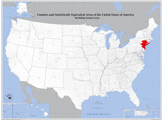
English: Map of Counties with New York Metropolitan Area highlighted. |
| Data | |
| Font | https://www2.census.gov/geo/maps/general_ref/us_base/stco2010/USstcou2010_wallmap.pdf |
| Autor | US Census Bureau, Edited by user Andololol to highlight New York Metropolitan Area. |
Llicència
This image or file is a work of a United States Census Bureau employee, taken or made as part of that person's official duties. As a work of the U.S. federal government, the image is in the public domain.
|
 |
Historial del fitxer
Cliqueu una data/hora per veure el fitxer tal com era aleshores.
| Data/hora | Miniatura | Dimensions | Usuari/a | Comentari | |
|---|---|---|---|---|---|
| actual | 21:20, 8 des 2020 | | 4.200 × 3.105 (2,72 Mo) | Brianski | file is painfully slow to download; remove alpha channel, light optimization |
| 05:18, 25 març 2016 |  | 4.200 × 3.105 (4,85 Mo) | Andololol | User created page with UploadWizard |
Ús del fitxer
La pàgina següent utilitza aquest fitxer:
Ús global del fitxer
Utilització d'aquest fitxer en altres wikis:
- Utilització a ar.wikipedia.org
- Utilització a ast.wikipedia.org
- Utilització a bg.wikipedia.org
- Utilització a bn.wikipedia.org
- Utilització a en.wikipedia.org
- Utilització a eo.wikipedia.org
- Utilització a et.wikipedia.org
- Utilització a fa.wikipedia.org
- Utilització a fi.wikipedia.org
- Utilització a fr.wikipedia.org
- Utilització a he.wikipedia.org
- Utilització a ko.wikipedia.org
- Utilització a pt.wikipedia.org
- Utilització a sh.wikipedia.org
- Utilització a tl.wikipedia.org
- Utilització a uk.wikipedia.org
- Utilització a www.wikidata.org