Fitxer original(fitxer SVG, nominalment 1.003 × 601 píxels, mida del fitxer: 183 Ko)

Dibuixa aquesta imatge en .
Descripció a Commons

Resum

Descripció
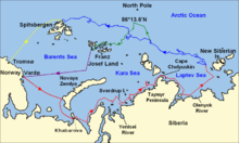
English: Map of the Arctic Ocean showing the routes taken during the 1893–96 Nansen's Fram expedition:
 
Frams's route eastward from Vardø to the Siberian coast, turning north at the New Siberian Islands to enter the pack ice. July – September 1893
 
Fram's drift in the ice from the New Siberian Islands, north and west to Spitsbergen, September 1893 – August 1896
 
Nansen and Johansen's march to Farthest North, 80°20'N, and their subsequent retreat to Cape Flora in Franz Josef Land. February 1895 – June 1896
 
Nansen and Johansen's return to Vardø from Cape Flora, August 1896
 
Fram's voyage from Spitsbergen to Tromsø, August 1896
Data
Font

Own work using:

Autor User:fremantleboy, User:NormanEinstein, Ruhrfisch
Permís
(Com reutilitzar aquest fitxer)
GFDL, CC-BY-SA
Altres versions

Derivative works of this file:  Nansen Fram Expedition map-fr.svg

png version

Llicència

Jo, el titular dels drets d'autor d'aquest treball, el public sota les següents llicències:
GNU head S'autoritza la còpia, la distribució i la modificació d'aquest document sota els termes de la llicència de documentació lliure GNU versió 1.2 o qualsevol altra versió posterior que publiqui la Free Software Foundation; sense seccions invariants, ni textos de portada, ni textos de contraportada. S'inclou una còpia d'aquesta llicència en la secció titulada GNU Free Documentation License.
w:ca:Creative Commons
reconeixement compartir igual
This file is licensed under the Creative Commons Attribution-Share Alike 4.0 International, 3.0 Unported, 2.5 Generic, 2.0 Generic and 1.0 Generic license.
Sou lliure de:
  • compartir – copiar, distribuir i comunicar públicament l'obra
  • adaptar – fer-ne obres derivades
Amb les condicions següents:
  • reconeixement – Heu de donar la informació adequada sobre l'autor, proporcionar un enllaç a la llicència i indicar si s'han realitzat canvis. Podeu fer-ho amb qualsevol mitjà raonable, però de cap manera no suggereixi que l'autor us dóna suport o aprova l'ús que en feu.
  • compartir igual – Si modifiqueu, transformeu, o generareu amb el material, haureu de distribuir les vostres contribucions sota una llicència similar o una de compatible com l'original
Podeu seleccionar la llicència que vulgueu.

Llegendes

Afegeix una explicació d'una línia del que representa aquest fitxer

Elements representats en aquest fitxer

representa l'entitat

Historial del fitxer

Cliqueu una data/hora per veure el fitxer tal com era aleshores.

Data/horaMiniaturaDimensionsUsuari/aComentari
actual18:21, 21 set 2022Miniatura per a la versió del 18:21, 21 set 20221.003 × 601 (183 Ko)Andrei StroeFile uploaded using svgtranslate tool (https://svgtranslate.toolforge.org/). Added translation for ro.
23:41, 15 set 2018Miniatura per a la versió del 23:41, 15 set 20181.003 × 601 (175 Ko)Jay D. EasyChanged yellow line to gold (ffff00 to ffd7000) to allow for easier legibility when combined with <nowiki>{{legend-line}}</nowiki> in captions, since a yellow line on a white background is often hard to make out.
19:03, 16 oct 2009Miniatura per a la versió del 19:03, 16 oct 20091.003 × 601 (175 Ko)BeaoTweak.
19:01, 16 oct 2009Miniatura per a la versió del 19:01, 16 oct 20091.003 × 601 (175 Ko)BeaoTweak.
18:58, 16 oct 2009Miniatura per a la versió del 18:58, 16 oct 20091.003 × 601 (175 Ko)BeaoRemoved flowRoot
18:49, 16 oct 2009Miniatura per a la versió del 18:49, 16 oct 20091.003 × 601 (190 Ko)BeaoRedrew lines and deleted link to image.
16:27, 16 oct 2009Miniatura per a la versió del 16:27, 16 oct 20091.052 × 744 (850 Ko)Ruhrfisch== Summary == {{Information |Description = Map of the Arctic Ocean showing the routes taken during the 1893–96 Nansen's Fram expedition: {{legend|red|Frams's route eastward from Vardø to the Siberian coast, turning nort

La pàgina següent utilitza aquest fitxer:

Ús global del fitxer

Utilització d'aquest fitxer en altres wikis:

Metadades