Fitxer:North Sea Mine Barrage map 1918.png

Mida d'aquesta previsualització: 490 × 599 píxels. Altres resolucions: 196 × 240 píxels | 392 × 480 píxels | 902 × 1.103 píxels.
Fitxer original (902 × 1.103 píxels, mida del fitxer: 234 Ko, tipus MIME: image/png)
| Aquest fitxer i la informació mostrada a continuació provenen del dipòsit multimèdia lliure Wikimedia Commons. |
Resum
| Descripció |
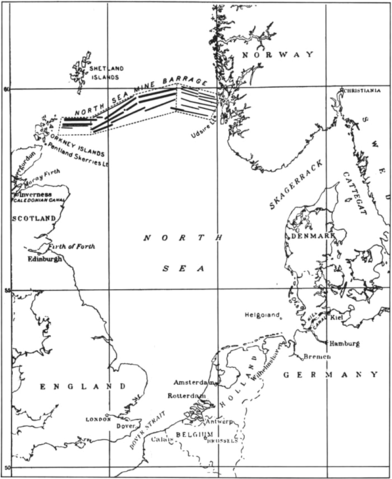
English: Map of the North Sea Mine Barrage, laid in the Summer of 1918. The mine barrage consisted of 18 rows of mines laid in an east-west direction between the Orkneys and Norway. The minefield was laid by British and U.S. ships. 56,571 of the 70,177 mines were deployed by the U.S. Navy. |
| Data | |
| Font | U.S. Navy All Hands magazine April 1986, p. 20. |
| Autor | U.S. Navy |
Llicència
Aquesta imatge és obra d'un mariner o empleat de l'U.S. Navy feta durant la prestació oficial de servei. Com a obra del govern federal dels EUA, la imatge és en el domini públic.
|
 | |
| Aquest fitxer està identificat com a lliure de restriccions conegudes sota la llei de drets d'autor, inclosos els drets veïns. | ||
Historial del fitxer
Cliqueu una data/hora per veure el fitxer tal com era aleshores.
| Data/hora | Miniatura | Dimensions | Usuari/a | Comentari | |
|---|---|---|---|---|---|
| actual | 19:45, 3 gen 2015 | | 902 × 1.103 (234 Ko) | Cobatfor | == {{int:filedesc}} == {{Information |Description={{en|1=Map of the North Sea Mine Barrage, laid in the Summer of 1918. The mine barrage consisted of 18 rows of mines laid in an east-west direction between the Orkneys and Norway. The minefield was laid... |
Ús del fitxer
Les 2 pàgines següents utilitzen aquest fitxer:
Ús global del fitxer
Utilització d'aquest fitxer en altres wikis:
- Utilització a ar.wikipedia.org
- Utilització a de.wikipedia.org
- Utilització a en.wikipedia.org
- Utilització a fr.wikipedia.org
- Utilització a hu.wikipedia.org
- Utilització a pl.wikipedia.org
- Utilització a ru.wikipedia.org
- Utilització a uk.wikipedia.org
- Utilització a www.wikidata.org