Fitxer:Okavango Delta map.png

Fitxer original (1.860 × 1.916 píxels, mida del fitxer: 733 Ko, tipus MIME: image/png)
| Aquest fitxer i la informació mostrada a continuació provenen del dipòsit multimèdia lliure Wikimedia Commons. |
| Descripció |
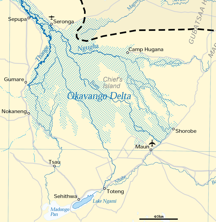
Deutsch: Karte des Okawangodeltas (vergrößerter Ausschnitt aus Datei Okavango River Basin map.png). Detaillierte Kartenlegende siehe dort.
English: Map of the Okavango delta (Botswana), expanded part of File:Okavango River Basin map.png. For detailled map legend see there.
|
| Data | |
| Font | http://www.un.org/Depts/Cartographic/map/profile/okavango.pdf (part) |
| Autor | United Nations |
| Permís (Com reutilitzar aquest fitxer) |
UN map as PD |
| Altres versions |
 |
| This image is a map derived from a United Nations map.
Unless stated otherwise, UN maps are to be considered in the public domain. This applies worldwide. UN maps are, in principle, open source material and you can use them in your work or for making your own map. UN requests however that you delete the UN name, logo and reference number upon any modification to the map. Content of your map will be your responsibility. You can state in your publication, if you wish, something like: based on UN map … (map name, map number, revision number and date). See: Geospatial Information Section. And: Geospatial, location data for a better world. |
 |
Historial del fitxer
Cliqueu una data/hora per veure el fitxer tal com era aleshores.
| Data/hora | Miniatura | Dimensions | Usuari/a | Comentari | |
|---|---|---|---|---|---|
| actual | 19:54, 27 juny 2018 | | 1.860 × 1.916 (733 Ko) | Antonsusi | adding a scale |
| 08:45, 5 abr 2016 |  | 1.860 × 1.916 (427 Ko) | RokerHRO | optipng -zc1-9 -zm1-9 -zs0-3 -f0-5 -i0 → 41.70% decrease | |
| 14:55, 17 març 2012 |  | 1.860 × 1.916 (733 Ko) | Antonsusi | {{UN map}} |
Ús del fitxer
La pàgina següent utilitza aquest fitxer:
Ús global del fitxer
Utilització d'aquest fitxer en altres wikis:
- Utilització a af.wikipedia.org
- Utilització a ar.wikipedia.org
- Utilització a avk.wikipedia.org
- Utilització a az.wikipedia.org
- Utilització a bh.wikipedia.org
- Utilització a bn.wikipedia.org
- Utilització a cs.wikipedia.org
- Utilització a da.wikipedia.org
- Utilització a de.wikipedia.org
- Utilització a en.wikipedia.org
- Utilització a eo.wikipedia.org
- Utilització a es.wikipedia.org
- Utilització a et.wikipedia.org
- Utilització a fi.wikipedia.org
- Utilització a fr.wikipedia.org
- Utilització a hr.wikipedia.org
- Utilització a incubator.wikimedia.org
- Utilització a ka.wikipedia.org
- Utilització a ml.wikipedia.org
- Utilització a mt.wikipedia.org
- Utilització a nl.wikipedia.org
- Utilització a pl.wikipedia.org
- Utilització a pt.wikipedia.org
- Utilització a ru.wikipedia.org
- Utilització a sh.wikipedia.org
- Utilització a sk.wikipedia.org
- Utilització a sl.wikipedia.org
- Utilització a sv.wikipedia.org
- Utilització a ta.wikipedia.org
- Utilització a tr.wikipedia.org
- Utilització a uk.wikipedia.org
- Utilització a vi.wikipedia.org
- Utilització a xmf.wikipedia.org
- Utilització a zh.wikipedia.org