Fitxer:Red dawn 1984 movie start of ww3.PNG

Mida d'aquesta previsualització: 800 × 359 píxels. Altres resolucions: 320 × 144 píxels | 640 × 287 píxels | 1.400 × 628 píxels.
Fitxer original (1.400 × 628 píxels, mida del fitxer: 49 Ko, tipus MIME: image/png)
| Aquest fitxer i la informació mostrada a continuació provenen del dipòsit multimèdia lliure Wikimedia Commons. |

|
This map, as well as other fictitious maps, is fictitious or too incorrect (i.e. due to anachronism) to be used in real-life contexts (contemporary or historic). It may have some visual elements that are similar to official maps such as colors or certain layout features, but they are NOT official and don't have any official recognition. |
Resum
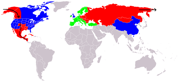
Map of fictional events in the 1984 movie Red Dawn, at the start of World War III.
- Blue = US and allies (United Kingdom "England", China "600 million screaming Chinamen", presumably Unoccupied Canada)
- Green = Neutral (Europe, "they're sitting this one out")
- Red = USSR and allies (showing USSR invasion of Alaska "stopped butt cold" at the contiguous 48 US border, Occupied Canadian Provinces of British Columbia, Western portion of Alberta and the Yukon Territory, Honduras, El Salvador, and Guatemala fall, Mexico in revolution, Texas described as being behind enemy lines, Oklahoma and most of Kansas, Louisiana, Arkansas, and Missouri probably overrun too, Colorado where the movie is set - invasion force stopped at Cheyenne, Wyoming. Blue circle shows Denver under siege.)
- Grey = Unknown
- Red squares = use of Soviet nuclear weapons - Beijing "there were", Washington, Kansas City & Omaha
At the end of the movie the US is implied on a plaque as having won the war, although how they did it is not explained.
If The US stopped them at the Mississippi River, then the color used for the US state Mississippi is incorrect. Mississippi would be part of F.A. (Free America) not occupied as the map indicates.
Llicència

|
S'autoritza la còpia, la distribució i la modificació d'aquest document sota els termes de la llicència de documentació lliure GNU versió 1.2 o qualsevol altra versió posterior que publiqui la Free Software Foundation; sense seccions invariants, ni textos de portada, ni textos de contraportada. S'inclou una còpia d'aquesta llicència en la secció titulada GNU Free Documentation License. |
| Aquest fitxer està subjecte a la llicència de Creative Commons Reconeixement i Compartir Igual 3.0 No adaptada. | ||
| ||
| Aquest avís de llicència s'ha afegit a aquest fitxer d'acord amb l'actualització de la llicència GFDL. |

|
Aquesta imatge (de tipus fictional map) s'hauria de tornar a crear utilitzant gràfics vectorials com ara un fitxer SVG. Això té diversos avantatges; en trobareu més informació a Commons:Media for cleanup. Si ja disposeu d'una versió d'aquesta imatge en format SVG, us preguem que la pengeu; després, reemplaceu aquesta plantilla amb la plantilla {{Vector version available|nom nou de la imatge.svg}} en aquesta imatge.
|
Historial del fitxer
Cliqueu una data/hora per veure el fitxer tal com era aleshores.
| Data/hora | Miniatura | Dimensions | Usuari/a | Comentari | |
|---|---|---|---|---|---|
| actual | 22:09, 23 des 2008 | | 1.400 × 628 (49 Ko) | Shibo77 | {{Information |Description=.. |Source=Roke |Date=.. |Author=Roke |Permission=.. |other_versions=.. }} <!--{{ImageUpload|basic}}--> |
| 14:36, 18 juny 2008 |  | 1.400 × 628 (49 Ko) | Peephole | {{Information |Description= |Source= |Date= |Author= |Permission= |other_versions= }} | |
| 03:14, 5 oct 2007 |  | 1.400 × 628 (49 Ko) | Hoshie | added Cabinda (between Angola and Zaire), fixed YAR/PDRY boundary. | |
| 21:17, 10 set 2007 |  | 1.400 × 628 (49 Ko) | Bart133 | == Summary == Map of fictional events in 1984 movie Red Dawn, at the start of World War III *Blue = US and allies (United Kingdom, China "600 million screaming Chinamen", presumably Unoccupied Canada) *Green = Neutral (Europe, "they're sitting this one o | |
| 02:54, 13 abr 2006 |  | 1.400 × 628 (49 Ko) | Roke~commonswiki | Map of fictional events in 1984 movie Red Dawn, at the start of World War III Blue = US and allies (England, China "600 million screaming Chinamen", presumably Canada) Green = Neutral (Europe, "theyre sitting this one out") Red = USSR and allies (showing |
Ús del fitxer
La pàgina següent utilitza aquest fitxer:
Ús global del fitxer
Utilització d'aquest fitxer en altres wikis:
- Utilització a ar.wikipedia.org
- Utilització a cy.wikipedia.org
- Utilització a de.wikipedia.org
- Utilització a en.wikipedia.org
- Utilització a eo.wikipedia.org
- Utilització a es.wikipedia.org
- Utilització a eu.wikipedia.org
- Utilització a fi.wikipedia.org
- Utilització a fr.wikipedia.org
- Utilització a id.wikipedia.org
- Utilització a it.wikipedia.org
- Utilització a ja.wikipedia.org
- Utilització a ko.wikipedia.org
- Utilització a ms.wikipedia.org
- Utilització a nds.wikipedia.org
- Utilització a nl.wikipedia.org
- Utilització a no.wikipedia.org
- Utilització a pl.wikipedia.org
- Utilització a pt.wikipedia.org
- Utilització a ru.wikipedia.org
- Utilització a simple.wikipedia.org
- Utilització a sv.wikipedia.org
- Utilització a uk.wikipedia.org
- Utilització a zh.wikipedia.org