Fitxer:Roman expansion 264 BC Shepherd.jpg

Fitxer original (2.302 × 1.812 píxels, mida del fitxer: 873 Ko, tipus MIME: image/jpeg)
| Aquest fitxer i la informació mostrada a continuació provenen del dipòsit multimèdia lliure Wikimedia Commons. |
This image was copied from wikipedia:de. The original description was:
| Descripció |
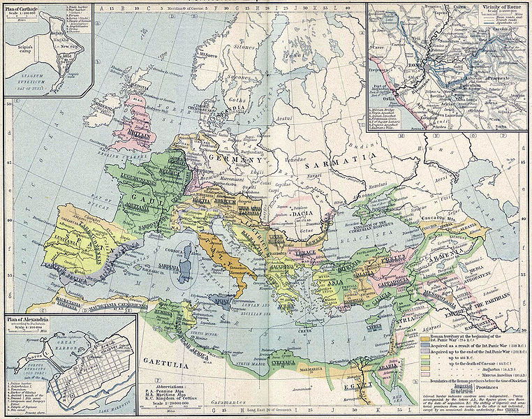
English: Roman territory, from the beginning of the 1st punic war (264 B.C.) to the death of Diocletian
Deutsch: Römisches Reich vom Beginn des 1. Punischen Kriegs (264 v.Chr.) bis zum Tod von Diokletian (312) im Historischen Atlas von William R. Shepherd (1923) |
| Data | 1923 |
| Font | "Historical Atlas" by William R. Shepherd, New York, Henry Holt and Company |
| Autor | William R. Shepherd |
| Altres versions |
|
Aquest material està en domini públic als Estats Units i als altres països on el dret d'autor s'estén per 70 anys (o menys) després de la mort de l'autor.
| |
| Aquest fitxer està identificat com a lliure de restriccions conegudes sota la llei de drets d'autor, inclosos els drets veïns. | |
| date/time | username | edit summary |
|---|---|---|
| 18:08, 21. Feb 2005 | Benowar | ("Historical Atlas" by William R. Shepherd, New York, Henry Holt and Company, 1923 PUBLIC DOMAIN) |
Historial del fitxer
Cliqueu una data/hora per veure el fitxer tal com era aleshores.
| Data/hora | Miniatura | Dimensions | Usuari/a | Comentari | |
|---|---|---|---|---|---|
| actual | 19:08, 18 abr 2006 | | 2.302 × 1.812 (873 Ko) | Crux | verbesserte Version |
| 18:53, 18 abr 2006 |  | 2.302 × 1.812 (767 Ko) | Crux | This image was copied from wikipedia:de. The original description was: {{Information| |Description=Roman territory at the beginning of the 1st punic war (264 B.C.) |Source="Historical Atlas" by William R. Shepherd, New York, Henry Holt and Company |Date= |
Ús del fitxer
Les 2 pàgines següents utilitzen aquest fitxer:
Ús global del fitxer
Utilització d'aquest fitxer en altres wikis:
- Utilització a ast.wikipedia.org
- Utilització a ba.wikipedia.org
- Utilització a bn.wikipedia.org
- Utilització a br.wikipedia.org
- Utilització a de.wikipedia.org
- Utilització a de.wikibooks.org
- Utilització a en.wikipedia.org
- Utilització a es.wikipedia.org
- Utilització a fr.wikipedia.org
- Utilització a fy.wikipedia.org
- Utilització a it.wikipedia.org
- Utilització a it.wikibooks.org
- Utilització a lv.wikipedia.org
- Utilització a mk.wikipedia.org
- Utilització a mwl.wikipedia.org
- Utilització a pnb.wikipedia.org
- Utilització a pt.wikipedia.org
- Utilització a ru.wikipedia.org
- Utilització a sa.wikipedia.org
- Utilització a skr.wikipedia.org
- Utilització a sk.wikipedia.org
- Utilització a sl.wikipedia.org
- Utilització a sq.wikipedia.org
- Utilització a ur.wikipedia.org
- Utilització a vi.wikipedia.org
- Utilització a zh.wikipedia.org