Fitxer:Ryknild street.jpg
No hi ha cap versió amb una resolució més gran.
Ryknild_street.jpg (640 × 480 píxels, mida del fitxer: 175 Ko, tipus MIME: image/jpeg)
| Aquest fitxer i la informació mostrada a continuació provenen del dipòsit multimèdia lliure Wikimedia Commons. |
| Descripció |
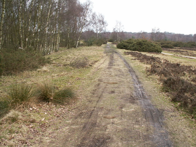
Ryknild Street Roman Road, Sutton Park. Ryknild Street Roman Road, Sutton Park Looking north east. The 1.5 mile section of the Roman road that runs through Sutton Park is one of the best preserved in the country, clearly showing the constructional features typical of roads in this part of the empire. This section of road linked the forts at Metcley (Birmingham) and Wall near Lichfield. |
| Data | |
| Font | From geograph.org.uk |
| Autor | Phil Champion |
| Permís (Com reutilitzar aquest fitxer) |
Creative Commons Attribution Share-alike license 2.0 |
| Posició de la càmera | | Aquesta i altres imatges properes a: OpenStreetMap |
|---|

|
Aquesta imatge prové de la col·lecció del projecte Geograph British Isles. Vegeu la pàgina d'aquesta fotografia al lloc web Geograph per a més informació del fotògraf. El titular dels drets d'autor d'aquesta imatge és Phil Champion i autoritza utilitzar-la sota la llicència Reconeixement-CompartirIgual 2.0 de Creative Commons.
|
Aquest fitxer està publicat sota la llicència de Creative Commons Reconeixement i Compartir Igual 2.0 Genèrica.
Reconeixement: Phil Champion
- Sou lliure de:
- compartir – copiar, distribuir i comunicar públicament l'obra
- adaptar – fer-ne obres derivades
- Amb les condicions següents:
- reconeixement – Heu de donar la informació adequada sobre l'autor, proporcionar un enllaç a la llicència i indicar si s'han realitzat canvis. Podeu fer-ho amb qualsevol mitjà raonable, però de cap manera no suggereixi que l'autor us dóna suport o aprova l'ús que en feu.
- compartir igual – Si modifiqueu, transformeu, o generareu amb el material, haureu de distribuir les vostres contribucions sota una llicència similar o una de compatible com l'original
Historial del fitxer
Cliqueu una data/hora per veure el fitxer tal com era aleshores.
| Data/hora | Miniatura | Dimensions | Usuari/a | Comentari | |
|---|---|---|---|---|---|
| actual | 15:53, 31 des 2008 | | 640 × 480 (175 Ko) | Victuallers | {{Information |Description=Ryknild Street Roman Road, Sutton Park. Ryknild Street Roman Road, Sutton Park Looking north east. The 1.5 mile section of the Roman road that runs through Sutton Park is one of the best preserved in the co |
Ús del fitxer
La pàgina següent utilitza aquest fitxer:
Ús global del fitxer
Utilització d'aquest fitxer en altres wikis:
- Utilització a be-tarask.wikipedia.org
- Utilització a cs.wikipedia.org
- Utilització a en.wikipedia.org
- Utilització a es.wikipedia.org
- Utilització a fi.wikipedia.org
- Utilització a fr.wikipedia.org
- Utilització a it.wikipedia.org
- Utilització a la.wikipedia.org
- Utilització a no.wikipedia.org
- Utilització a pt.wikipedia.org
- Utilització a ru.wikipedia.org
- Utilització a simple.wikipedia.org
- Utilització a www.wikidata.org