Fitxer:Sámova říše.png

Mida d'aquesta previsualització: 601 × 600 píxels. Altres resolucions: 241 × 240 píxels | 481 × 480 píxels | 852 × 850 píxels.
Fitxer original (852 × 850 píxels, mida del fitxer: 184 Ko, tipus MIME: image/png)
| Aquest fitxer i la informació mostrada a continuació provenen del dipòsit multimèdia lliure Wikimedia Commons. |

|
Aquesta imatge (de tipus mapa) s'hauria de tornar a crear utilitzant gràfics vectorials com ara un fitxer SVG. Això té diversos avantatges; en trobareu més informació a Commons:Media for cleanup. Si ja disposeu d'una versió d'aquesta imatge en format SVG, us preguem que la pengeu; després, reemplaceu aquesta plantilla amb la plantilla {{Vector version available|nom nou de la imatge.svg}} en aquesta imatge.
|
| Descripció |
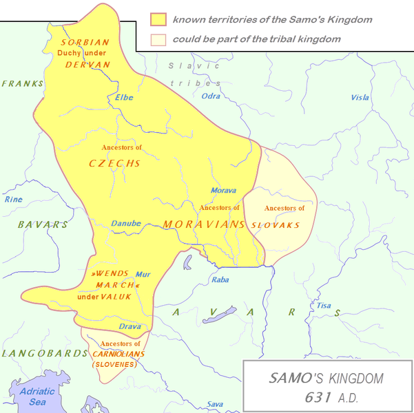
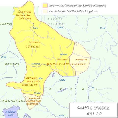
English: Tribal Kingdom of Samo.
Map is based on the maps in:
It is also based on descriptions in:
For eastern and southern extant of tribal kingdom: known territories are shown by the scheme of franco-slavic border and information about the conflicts with Avars is imlemented. The inclusion of Bohemian basin is followed. Contacts with Avars are reached through the territory of Moravians and Eastern Alps. The territories further east and south, which are in proximity of Avars, could be parts of tribal kingdom, too. |
| Data | (UTC) |
| Font | |
| Autor |
|
| Això és una imatge retocada, cosa que vol dir que ha estat alterada digitalment de la seva versió original. Modificacions: The map of Danube basin was used to create map of Kingdom of Samo. L'original es pot veure a: Tribal Kingdom of Samo-sl version.PNG:
|
Jo, el titular dels drets d'autor d'aquest treball, el public sota la següent llicència:
| Jo, el titular del copyright d'aquesta obra, l'allibero al domini públic. Això s'aplica a tot el món. En alguns països això pot no ser legalment possible, en tal cas: Jo faig concessió a tothom del dret d'usar aquesta obra per a qualsevol propòsit, sense cap condició llevat d'aquelles requerides per la llei. |
Registre original de càrregues
This image is a derivative work of the following images:
- File:Waterways_of_SE_Central_Europe.svg licensed with PD-self
- 2010-01-08T20:49:27Z Kmiki87 1415x1059 (292577 Bytes) {{Information |Description={{en|1=Waterways along the central and lower Danube, including the Bohemian and Carpathian Basins, the northern Balkans, parts of Austria, southern Poland and Western Ukraine.}} |Source={{own}} |Aut
Historial del fitxer
Cliqueu una data/hora per veure el fitxer tal com era aleshores.
| Data/hora | Miniatura | Dimensions | Usuari/a | Comentari | |
|---|---|---|---|---|---|
| actual | 16:27, 3 gen 2013 | | 852 × 850 (184 Ko) | DancingPhilosopher | Better map based on http://commons.wikimedia.org/wiki/File:Tribal_Kingdom_of_Samo-sl_version.PNG |
| 16:13, 28 oct 2010 |  | 536 × 474 (616 Ko) | Aktron | == {{int:filedesc}} == {{OpenStreetMap|name=Sámova říše}} Category:Maps of the history of Austria Category:Maps of the history of Slovakia Category:Maps of the history of Slovenia [[Category:Maps of the history of the Czech Republic |
Ús del fitxer
Les 4 pàgines següents utilitzen aquest fitxer:
Ús global del fitxer
Utilització d'aquest fitxer en altres wikis:
- Utilització a ar.wikipedia.org
- Utilització a azb.wikipedia.org
- Utilització a az.wikipedia.org
- Utilització a be.wikipedia.org
- Utilització a bg.wikipedia.org
- Utilització a cs.wikipedia.org
- Utilització a de.wikipedia.org
- Utilització a de.wikibooks.org
- Utilització a en.wikipedia.org
- Utilització a et.wikipedia.org
- Utilització a fa.wikipedia.org
- Utilització a fr.wikipedia.org
- Utilització a hy.wikipedia.org
- Utilització a id.wikipedia.org
- Utilització a it.wikipedia.org
- Utilització a ja.wikipedia.org
- Utilització a lfn.wikipedia.org
- Utilització a lv.wikipedia.org
Vegeu més usos globals d'aquest fitxer.