Fitxer:Salar de Atacama, Chile - NASA Earth Observatory.jpg
Fitxer original (4.007 × 4.007 píxels, mida del fitxer: 5,15 Mo, tipus MIME: image/jpeg)
| Aquest fitxer i la informació mostrada a continuació provenen del dipòsit multimèdia lliure Wikimedia Commons. |
Resum
| Descripció |
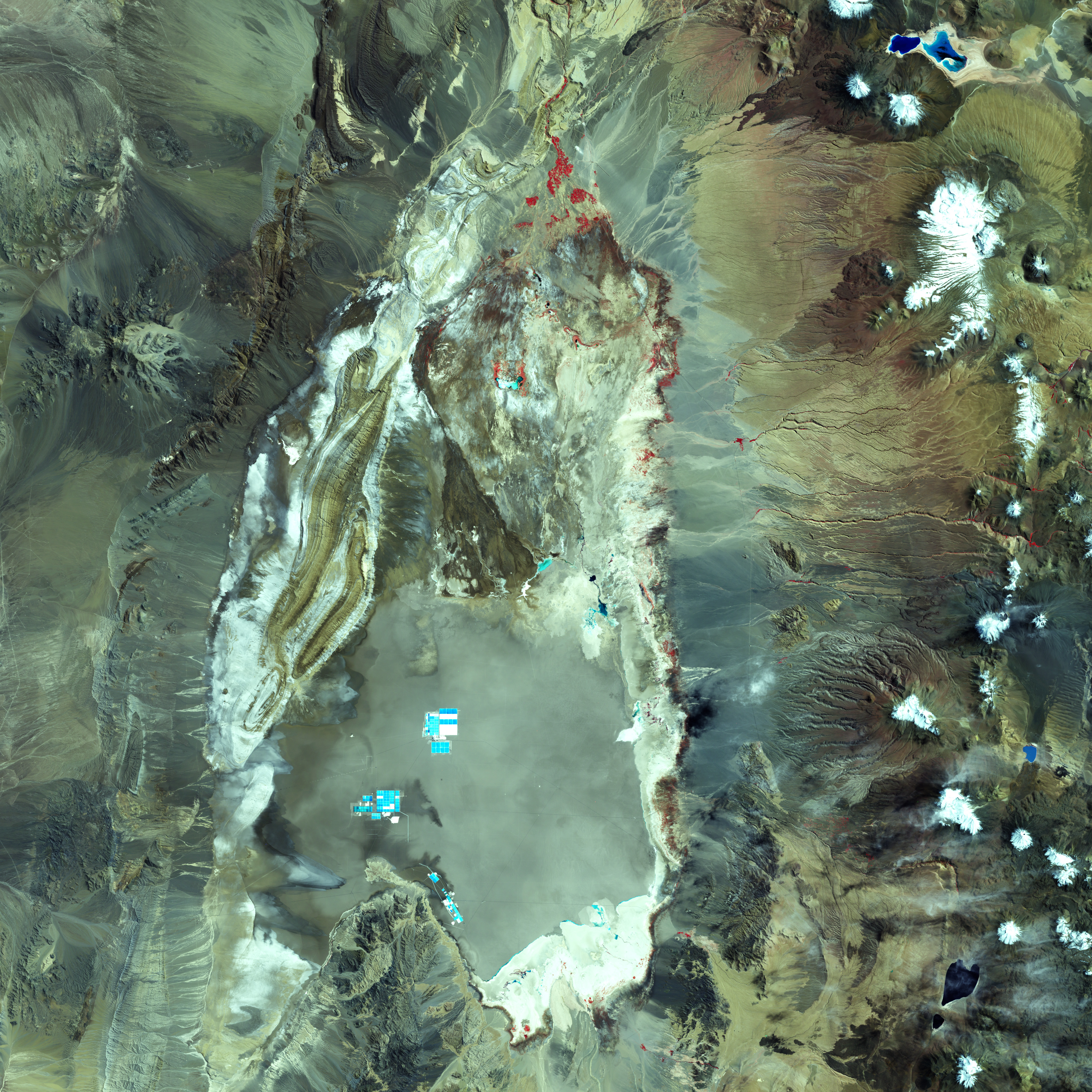
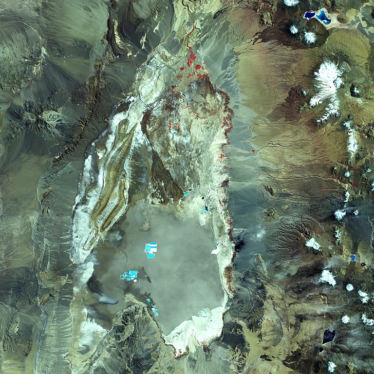
To download the full resolution and other files go to: earthobservatory.nasa.gov/IOTD/view.php?id=76518&src=... Chile’s Atacama Desert may be the driest place on Earth. Large stretches of the Atacama have gone without moisture for as long as people have been keeping track. Yet some precipitation does fall in the region, and that water helps shape the landscape. Within this arid environment lies a salt flat, or playa, named Salar de Atacama. The Landsat 7 satellite acquired this false-color image on March 21, 2002. Red indicates vegetation, the most abundant of which occurs around springs that dot the northern edge of the saltpan. Nearby soils that support some vegetation appear tan and brown. Although it sits at a much higher elevation, the Salar de Atacama resembles California’s Death Valley as a flat area in between mountain ranges. The little precipitation that has fallen has usually drained off the mountains and flowed into nearby valleys, creating alluvial fans. The salt flat is a geologically young, dynamic system. Occasional floods do reach the saltpan, and flood waters carry gravel, sand, clay, and salt. Heavier materials such as gravel and sand tend to drop out of the water sooner, coming to rest outside the saltpan. Clays and salts can hitch a ride all the way to the playa. Floods initially stir the sediments inside Salar de Atacama, but material eventually settles into layers of clay and salty water. Because the playa lacks drainage, water only leaves by evaporation. As it evaporates, salts remain behind and form crusts. Inside the saltpan, mottled light blue indicates surface salt crusts. The white color around the perimeter of the saltpan indicates a zone of clay and carbonate-rich material that alternately forms a crust on the surface and re-dissolves with rising and falling groundwater. Northeast of the playa, white indicates something else: snow and ice on the volcanic peaks. Volcanic rocks and soils range in color from burnt orange to tan. Around the playa, the false-color green indicates rocks that would appear red to human eyes. Blue indicates older sedimentary rocks (deposited by wind and water) and igneous rocks (formed from cooling lava or magma) that support no vegetation. Not surprisingly, Salar de Atacama is now mined for salt, and evaporation ponds appear in the middle of the saltpan—rectangular shapes of bright turquoise and white. The salt flat also holds the potential for lithium production from its subsurface brine-bearing waters. NASA Earth Observatory image created by Jesse Allen, using Landsat data provided by the United States Geological Survey. Caption by Michon Scott, based on image interpretation by Eric Livo and Dan Knepper, U.S. Geological Survey. The Earth Observatory's mission is to share with the public the images, stories, and discoveries about climate and the environment that emerge from NASA research, including its satellite missions, in-the-field research, and climate models. |
| Data | |
| Font | Salar de Atacama, Chile |
| Autor | NASA's Earth Observatory |
| Posició de la càmera | | Aquesta i altres imatges properes a: OpenStreetMap |
|---|
Llicència
- Sou lliure de:
- compartir – copiar, distribuir i comunicar públicament l'obra
- adaptar – fer-ne obres derivades
- Amb les condicions següents:
- reconeixement – Heu de donar la informació adequada sobre l'autor, proporcionar un enllaç a la llicència i indicar si s'han realitzat canvis. Podeu fer-ho amb qualsevol mitjà raonable, però de cap manera no suggereixi que l'autor us dóna suport o aprova l'ús que en feu.
| This image was originally posted to Flickr by NASA Earth Observatory at https://www.flickr.com/photos/68824346@N02/6425749327. It was reviewed on 2 de juliol de 2012 by FlickreviewR and was confirmed to be licensed under the terms of the cc-by-2.0. |
| Anotacions | Aquesta imatge té anotacions: Vegeu-les a Commons |

.jpg)
Historial del fitxer
Cliqueu una data/hora per veure el fitxer tal com era aleshores.
| Data/hora | Miniatura | Dimensions | Usuari/a | Comentari | |
|---|---|---|---|---|---|
| actual | 18:28, 13 gen 2021 | | 4.007 × 4.007 (5,15 Mo) | Juan Villalobos | https://earthobservatory.nasa.gov/images/76518/salar-de-atacama-chile https://eoimages.gsfc.nasa.gov/images/imagerecords/76000/76518/atacama_etm_2002080_lrg.jpg |
| 19:18, 2 jul 2012 |  | 720 × 720 (240 Ko) | Dzlinker | == {{int:filedesc}} == {{Information |Description=To download the full resolution and other files go to: [http://earthobservatory.nasa.gov/IOTD/view.php?id=76518&src=flickr earthobservatory.nasa.gov/IOTD/view.php?id=76518&src=...] Chile’s Atacama De... |
Ús del fitxer
La pàgina següent utilitza aquest fitxer:
Ús global del fitxer
Utilització d'aquest fitxer en altres wikis:
- Utilització a de.wikipedia.org
- Utilització a en.wikipedia.org
- Utilització a es.wikipedia.org
- Utilització a fa.wikipedia.org
- Utilització a nl.wikipedia.org