Fitxer:Sea of Okhotsk Season Winter Summer 2008.jpg

Fitxer original(6.256 × 6.126 píxels, mida del fitxer: 8,89 Mo, tipus MIME: image/jpeg)

Descripció a Commons

Resum

Descripció
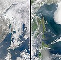
English: The Sea of Okhotsk in winter and summer 2008. The Sea of Okhotsk owes its seasonal swings to its geography. The Russian-administered Kurile Islands shelter the sea from the currents of the open Pacific Ocean to the east, while the islands of Japan block warm currents from the south. This limits the circulation of warm water through the sea. At the same time, the Amur River pours fresh water into the Sea of Okhotsk. The fresh water remains trapped in the top 50 meters (165 feet) of the sea by a layer of dense, cold, salty water. Winter brings frigid temperatures from Siberia, and the relatively fresh water near the sea’s surface freezes quickly.

On the other side of the pendulum is the ice-free and snow-free landscape of summer, shown in the lower image. Warm summer currents and a warm summer sun melt the ice, revealing open water and a green, forest-covered landscape. From the coast to the tree line, 90 percent of the Shiretoko Peninsula is covered with pristine vegetation ranging from a cool, broadleaf forest near the coast to an alpine coniferous forest in the mountains that run up the center of the peninsula. The bare, rocky mountain tops are above the tree line and are tan in this photo-like image.

This wilderness is an oasis for wildlife. During the winter, ice algae grow in the mineral-rich waters under the ice. As the ice melts, other forms of phytoplankton flourish. The highly productive waters sustain a diverse and thriving ecosystem. According to the United Nations, the phytoplankton and the zooplankton that eat the phytoplankton are at the base of the food chain for 28 species of marine mammals and 223 species of marine fish. Since the region depends on the annual sea ice, it is particularly prone to global warming.

The Moderate Resolution Imaging Spectroradiometer (MODIS) on NASA’s Aqua satellite captured these images on March 8, 2008, top, and June 5, 2008, bottom.
日本語: オホーツク海の季節:冬と夏(2008年)
Data
Font The Earth Observatory - NASA - https://earthobservatory.nasa.gov/images/8893/shiretoko-peninsula
Autor Ocean Color Image Gallery. NASA. Accessed July 3, 2008.
Altres versions

Llicència

Public domain Aquest fitxer és en el domini públic perquè ha estat creat per la NASA. L'avís legal de la NASA diu que «el material de la NASA no està protegit per copyright si no es diu el contrari». (NASA copyright policy page o JPL Image Use Policy).
Atenció:
  • L'ús dels logotips de la NASA, insígnies i emblemes està restringit la llei dels EUA 14 CFR 1221.
  • El lloc web de la NASA disposa d'un gran nombre d'imatges de l'Agència Espacial Russa, o soviètica, i d'altres agències no nord-americanes. Aquestes imatges no són necessàriament en el domini públic.
  • El material del Telescopi espacial Hubble pot tenir els drets reservats si no prové explícitament del STScI. [1]
  • Tot el material de la sonda SOHO està reservat i requereix d'autorització per a un ús comercial no educatiu. [2]
  • Les imatges destacades en el lloc web Astronomy Picture of the Day (APOD) poden tenir drets d'autor. [3]

Llegendes

Afegeix una explicació d'una línia del que representa aquest fitxer
The Sea of Okhotsk in winter and summer, 2008.

Historial del fitxer

Cliqueu una data/hora per veure el fitxer tal com era aleshores.

Data/horaMiniaturaDimensionsUsuari/aComentari
actual07:58, 26 abr 2022Miniatura per a la versió del 07:58, 26 abr 20226.256 × 6.126 (8,89 Mo)ArtanisenUploaded a work by Ocean Color Image Gallery. NASA. Accessed July 3, 2008. from The Earth Observatory - NASA - https://earthobservatory.nasa.gov/images/8893/shiretoko-peninsula with UploadWizard

La pàgina següent utilitza aquest fitxer:

Ús global del fitxer

Utilització d'aquest fitxer en altres wikis:

Metadades