Fitxer:St. Martin.png

Mida d'aquesta previsualització: 800 × 566 píxels. Altres resolucions: 320 × 227 píxels | 640 × 453 píxels | 1.024 × 725 píxels | 1.280 × 906 píxels | 2.560 × 1.812 píxels | 5.563 × 3.938 píxels.
Fitxer original (5.563 × 3.938 píxels, mida del fitxer: 6,29 Mo, tipus MIME: image/png)
| Aquest fitxer i la informació mostrada a continuació provenen del dipòsit multimèdia lliure Wikimedia Commons. |
Resum
| Descripció |
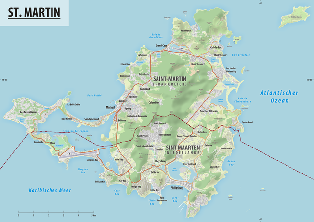
Deutsch: Reliefkarte des Grenzverlaufes zwischen Frankreich und der Niederlande |
||||||||
| Data | |||||||||
| Font | Treball propi, Hintergrund: Openstreetmap | ||||||||
| Autor | Tschubby | ||||||||
| Permís (Com reutilitzar aquest fitxer) |
Jo, el titular dels drets d'autor d'aquest treball, el public sota les següents llicències:
Aquest fitxer està llicenciat sota les llicències de Creative Commons Reconeixement - CompartirIgual 2.5 Genèrica, 2.0 Genèrica i 1.0 Genèrica.
Podeu seleccionar la llicència que vulgueu. |

Historial del fitxer
Cliqueu una data/hora per veure el fitxer tal com era aleshores.
| Data/hora | Miniatura | Dimensions | Usuari/a | Comentari | |
|---|---|---|---|---|---|
| actual | 10:54, 17 ago 2019 | | 5.563 × 3.938 (6,29 Mo) | Tschubby | {{Information |description= |date= |source= |author= |permission= |other versions= }} |
| 10:20, 17 ago 2019 |  | 5.563 × 3.938 (6,29 Mo) | Tschubby | == {{int:filedesc}} == {{Information |Description= {{de| Reliefkarte des Grenzverlaufes zwischen Frankreich und Monaco}} |Source={{own}}, Hintergrund: [http://www.openstreetmap.org Openstreetmap] |Date= 2019-08-17 |Author= Tschubby |Permission= {{self|GFDL|Cc-by-sa-3.0-migrated|Cc-by-sa-2.5,2.0,1.0}} |other_versions= }} Category:Borders of France-Nederlands Category:Maps of borders of Nederlands Category:Maps of borders of France |
Ús del fitxer
La pàgina següent utilitza aquest fitxer:
Ús global del fitxer
Utilització d'aquest fitxer en altres wikis:
- Utilització a ar.wikipedia.org
- Utilització a de.wikipedia.org
- Utilització a gl.wikipedia.org
- Utilització a lb.wikipedia.org
- Utilització a tt.wikipedia.org
- Utilització a www.wikidata.org