Fitxer:Sudan agriculture Landsat.jpg

Fitxer original (1.200 × 905 píxels, mida del fitxer: 220 Ko, tipus MIME: image/jpeg)
| Aquest fitxer i la informació mostrada a continuació provenen del dipòsit multimèdia lliure Wikimedia Commons. |
Transwiki approved by: w:en:User:Dmcdevit
This image was copied from wikipedia:en. The original description was:
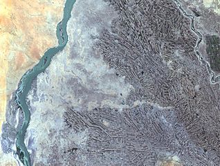
Farming along White and Blue Nile Rivers, near Khartoum, w:en:Sudan
In the Sahara Desert, along the White and Blue Nile rivers lies a thriving agricultural area. As seen in this Landsat 7 image, the farming patterns resemble French long farms, whose long, rectangular shapes allow each individual plot access to water from irrigation canals along the narrow side. The White Nile (left side of image) joins with the narrower Blue Nile (right side of image) a few miles further north at the city of Khartoum, Sudan, home to approximately 1 million of Sudan’s 33 million people. Sudan’s main crop is cotton, a very water-intensive crop for such an arid land. Surrounding Khartoum is the eastern Saharan Desert, noticeable as the reddish area in the upper left portion of the image.
http://landsat.usgs.gov/gallery/detail/384/
Aquesta imatge és de domini públic, ja que conté materials que originalment van venir del Servei Geològic dels Estats Units d'Amèrica, una agència del Departament de l'Interior dels Estats Units. Per a obtenir més informació, consulti la política oficial de drets de l'USGS.
|
Registre original de càrregues
| date/time | username | resolution | size | edit summary |
|---|---|---|---|---|
| 21:21, 24 October 2005 | w:en:User:Brian0918 | 1200×905 | 220 KB | Farming along White and Blue Nile Rivers, near Khartoum, <a href="/wiki/Sudan" title="Sudan">Sudan</a> In the Sahara Desert, along the White and Blue Nile rivers lies a thriving agricultural area. As seen in this Landsat 7 image, the farming patterns resemble French long farms, whose long, |
Image description page history
Historial del fitxer
Cliqueu una data/hora per veure el fitxer tal com era aleshores.
| Data/hora | Miniatura | Dimensions | Usuari/a | Comentari | |
|---|---|---|---|---|---|
| actual | 06:03, 16 set 2007 | | 1.200 × 905 (220 Ko) | BetacommandBot | Transwiki approved by: w:en:User:Dmcdevit This image was copied from wikipedia:en. The original description was: Farming along White and Blue Nile Rivers, near Khartoum, w:en:Sudan In the Sahara Desert, along the White and Blue Nile rivers lies |
Ús del fitxer
La pàgina següent utilitza aquest fitxer:
Ús global del fitxer
Utilització d'aquest fitxer en altres wikis:
- Utilització a ar.wikipedia.org
- Utilització a ast.wikipedia.org
- Utilització a en.wikipedia.org
- Utilització a es.wikipedia.org
- Utilització a fa.wikipedia.org
- Utilització a ig.wikipedia.org
- Utilització a sr.wikipedia.org