Fitxer:Tassili n’Ajjer National Park NASA Landsat 7 (2000).jpg

Fitxer original (6.357 × 4.869 píxels, mida del fitxer: 9,31 Mo, tipus MIME: image/jpeg)
| Aquest fitxer i la informació mostrada a continuació provenen del dipòsit multimèdia lliure Wikimedia Commons. |
| Descripció |
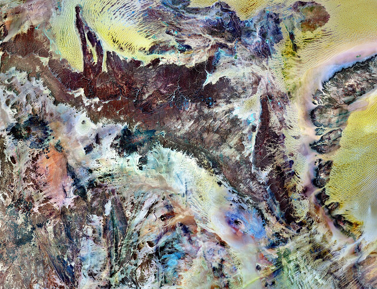
Tassili n’Ajjer National Park covers 72,000 square kilometers (27,800 square miles) in southeastern Algeria. Part of the Sahara Desert, the park has a bone-dry climate with scant rainfall, yet does not blend in with Saharan dunes. Instead, the rocky plateau rises above the surrounding sand seas. Rich in geologic and human history, Tassili n’Ajjer is a United Nations Educational, Scientific and Cultural Organization (UNESCO) World Heritage Site. This image is made from multiple observations by the Landsat 7 satellite in the year 2000. It uses a combination of infrared, near-infrared, and visible light to better distinguish between the park’s various rock types. Sand appears in shades of yellow and tan. Granite rocks appear brick red. Blue areas are likely salts. As the patchwork of colors suggests, the geology of Tassili n’Ajjer is complex. The plateau is composed of sandstone around a mass of granite dating from the Precambrian. Over billions of years, alternating wet and dry climates have shaped these rocks in multiple ways. Deep ravines are cut into cliff faces along the plateau’s northern margin. The ravines are remnants of ancient rivers that once flowed off the plateau into nearby lakes. Where those lakes once rippled, winds now sculpt the dunes of giant sand seas. In drier periods, winds eroded the sandstones of the plateau into “stone forests,” and natural arches. Not surprisingly, the park’s name means “plateau of chasms.” Humans have also modified the park’s rocks. Some 15,000 engravings have so far been identified in Tassili n’Ajjer. From about 10,000 B.C. to the first few centuries A.D., successive populations also left the remains of homes and burial mounds.
|
|||||
| Data | ||||||
| Font | NASA Earth Observation Image of the Day, 27 March 2011 | |||||
| Autor | NASA Landsat 7 image by Michael Taylor, Landsat Science Project Office. Caption by Michon Scott based on image interpretation by Michael Taylor. | |||||
| Permís (Com reutilitzar aquest fitxer) |
|

.jpg?uselang=ca)
| Posició de la càmera | | Aquesta i altres imatges properes a: OpenStreetMap |
|---|
.jpg¶ms=024.906667_N_0008.784444_E_globe:Earth_type:camera__&language=ca)
Historial del fitxer
Cliqueu una data/hora per veure el fitxer tal com era aleshores.
| Data/hora | Miniatura | Dimensions | Usuari/a | Comentari | |
|---|---|---|---|---|---|
| actual | 23:16, 29 gen 2013 | | 6.357 × 4.869 (9,31 Mo) | Slick-o-bot | Bot: convert to a non-interlaced jpeg (see bug #17645) |
| 12:24, 28 març 2011 |  | 6.357 × 4.869 (8,62 Mo) | Trialsanderrors | {{Information |Description= Tassili n’Ajjer National Park covers 72,000 square kilometers (27,800 square miles) in southeastern Algeria. Part of the Sahara Desert, the park has a bone-dry climate with scant rainfall, yet does not blend in with Saharan d |
Ús del fitxer
La pàgina següent utilitza aquest fitxer:
Ús global del fitxer
Utilització d'aquest fitxer en altres wikis:
- Utilització a el.wikipedia.org
- Utilització a en.wikipedia.org
- Utilització a es.wikipedia.org
- Utilització a eu.wikipedia.org
- Utilització a fa.wikipedia.org
- Utilització a hr.wikipedia.org
- Utilització a ml.wikipedia.org
- Utilització a mt.wikipedia.org
- Utilització a my.wikipedia.org
- Utilització a pnb.wikipedia.org
- Utilització a sh.wikipedia.org
- Utilització a simple.wikipedia.org
- Utilització a sl.wikipedia.org
- Utilització a war.wikipedia.org
- Utilització a www.wikidata.org
- Utilització a zh-yue.wikipedia.org
- Utilització a zh.wikipedia.org
.jpg)