Fitxer:The Portuguese Empire.png

Mida d'aquesta previsualització: 800 × 407 píxels. Altres resolucions: 320 × 163 píxels | 640 × 325 píxels | 1.024 × 521 píxels | 1.280 × 651 píxels | 2.753 × 1.400 píxels.
Fitxer original (2.753 × 1.400 píxels, mida del fitxer: 232 Ko, tipus MIME: image/png)
| Aquest fitxer i la informació mostrada a continuació provenen del dipòsit multimèdia lliure Wikimedia Commons. |

|
Aquesta imatge (de tipus locator map) s'hauria de tornar a crear utilitzant gràfics vectorials com ara un fitxer SVG. Això té diversos avantatges; en trobareu més informació a Commons:Media for cleanup. Si ja disposeu d'una versió d'aquesta imatge en format SVG, us preguem que la pengeu; després, reemplaceu aquesta plantilla amb la plantilla {{Vector version available|nom nou de la imatge.svg}} en aquesta imatge.
|
Resum
| Descripció |
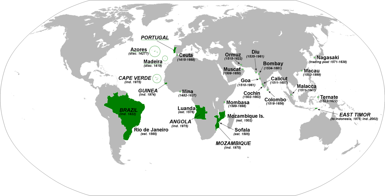
English: The principal forts, trading posts and colonies of the Portuguese Empire (1415-1999).
Abbreviations: disc: date of discovery est: date of establishment ind: date of independence Present-day Portuguese territory is underlined in green. |
| Data | |
| Font | Treball propi |
| Autor | The Red Hat of Pat Ferrick |
Llicència
| Jo, el titular del copyright d'aquesta obra, l'allibero al domini públic. Això s'aplica a tot el món. En alguns països això pot no ser legalment possible, en tal cas: Jo faig concessió a tothom del dret d'usar aquesta obra per a qualsevol propòsit, sense cap condició llevat d'aquelles requerides per la llei. |
Historial del fitxer
Cliqueu una data/hora per veure el fitxer tal com era aleshores.
| Data/hora | Miniatura | Dimensions | Usuari/a | Comentari | |
|---|---|---|---|---|---|
| actual | 03:46, 3 feb 2018 | | 2.753 × 1.400 (232 Ko) | 42800141 | Removed the state of Acre from the rest of Brazil and the border between Brazil and Uruguay |
| 04:02, 8 gen 2009 |  | 2.753 × 1.400 (214 Ko) | The Red Hat of Pat Ferrick | lose a few arrows | |
| 04:16, 5 gen 2009 |  | 2.753 × 1.400 (223 Ko) | The Red Hat of Pat Ferrick | forgot E. Timor | |
| 03:09, 5 gen 2009 |  | 2.753 × 1.400 (214 Ko) | The Red Hat of Pat Ferrick | Underlines for present day Portuguese territory | |
| 02:49, 5 gen 2009 |  | 2.753 × 1.400 (214 Ko) | The Red Hat of Pat Ferrick | Arrow for Ceuta | |
| 02:46, 5 gen 2009 |  | 2.753 × 1.400 (213 Ko) | The Red Hat of Pat Ferrick | {{Information |Description={{en|1=The principle forts, trading posts and colonies of the Portuguese Empire (1415-1999). Abbreviations: est: date of establishment ind: date of independence }} |Source=Own work |Author=[[User:The Red Hat of Pat Ferrick|The |
Ús del fitxer
La pàgina següent utilitza aquest fitxer:
Ús global del fitxer
Utilització d'aquest fitxer en altres wikis:
- Utilització a ar.wikipedia.org
- Utilització a de.wikipedia.org
- Utilització a el.wikipedia.org
- Utilització a en.wikipedia.org
- Utilització a en.wikibooks.org
- Utilització a et.wikipedia.org
- Utilització a fa.wikipedia.org
- Utilització a gl.wikipedia.org
- Utilització a id.wikipedia.org
- Utilització a incubator.wikimedia.org
- Utilització a it.wikipedia.org
- Utilització a pl.wikipedia.org
- Utilització a pt.wikibooks.org
- Utilització a qu.wikipedia.org
- Utilització a sc.wikipedia.org
- Utilització a uk.wikipedia.org
- Utilització a zh.wikibooks.org