Fitxer:Wartheland.png

Mida d'aquesta previsualització: 569 × 599 píxels. Altres resolucions: 228 × 240 píxels | 456 × 480 píxels | 729 × 768 píxels | 972 × 1.024 píxels | 1.682 × 1.772 píxels.
Fitxer original (1.682 × 1.772 píxels, mida del fitxer: 889 Ko, tipus MIME: image/png)
| Aquest fitxer i la informació mostrada a continuació provenen del dipòsit multimèdia lliure Wikimedia Commons. |
Resum
| Descripció |
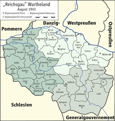
English: Map of "Reichsgau Wartheland", 1943
Deutsch: Karte des "Reichsgaus Wartheland", 1943 |
| Data | |
| Font | Treball propi |
| Autor | Kgberger |

|
This map has been made or improved in the German Kartenwerkstatt (Map Lab). You can propose maps to improve as well.
|
Llicència
| Jo, el titular del copyright d'aquesta obra, l'allibero al domini públic. Això s'aplica a tot el món. En alguns països això pot no ser legalment possible, en tal cas: Jo faig concessió a tothom del dret d'usar aquesta obra per a qualsevol propòsit, sense cap condició llevat d'aquelles requerides per la llei. |
Historial del fitxer
Cliqueu una data/hora per veure el fitxer tal com era aleshores.
| Data/hora | Miniatura | Dimensions | Usuari/a | Comentari | |
|---|---|---|---|---|---|
| actual | 19:23, 27 gen 2009 | | 1.682 × 1.772 (889 Ko) | Ziegelbrenner | {{Information |Description= |Source= |Date= |Author= |Permission= |other_versions= }} |
| 16:43, 26 gen 2009 |  | 1.772 × 1.772 (904 Ko) | Ziegelbrenner | {{Information |Description={{en|1=Map of "Reichsgau Wartheland", 1943}} {{de|1=Karte des "Reichsgaus Wartheland", 1943}} |Source=Eigenes Werk (own work) |Author=Kgberger |Date=2009-01-26 |Permission= |other_versions=unknown }} <!--{{Ima |
Ús del fitxer
Les 3 pàgines següents utilitzen aquest fitxer:
Ús global del fitxer
Utilització d'aquest fitxer en altres wikis:
- Utilització a de.wikipedia.org
- Landkreis Lentschütz
- Landkreis Kalisch
- Landkreis Konin
- Landkreis Hermannsbad
- Landkreis Warthbrücken
- Kreis Schrimm
- Kreis Schroda
- Kreis Wreschen
- Landkreis Birnbaum (Wartheland)
- Landkreis Samter
- Kreis Rawitsch
- Kreis Posen
- Kreis Obornik
- Landkreis Lissa (Wartheland)
- Landkreis Scharnikau (Wartheland)
- Kreis Krotoschin
- Landkreis Grätz (Wartheland)
- Kreis Jarotschin
- Landkreis Kosten (Wartheland)
- Landkreis Ostrowo
- Landkreis Altburgund
- Landkreis Dietfurt (Wartheland)
- Landkreis Eichenbrück
- Landkreis Gnesen
- Landkreis Hohensalza
- Landkreis Mogilno
- Landkreis Kutno
- Landkreis Waldrode
- Landkreis Leslau
- Landkreis Welun
- Landkreis Lask
- Landkreis Schieratz
- Landkreis Turek
- Landkreis Litzmannstadt
- Landkreis Wollstein
- Kreis Kolmar i. Posen
- Landkreis Gostingen
- Wikipedia:Kartenwerkstatt/Archiv/2009-01
- Regierungsbezirk Hohensalza
- Regierungsbezirk Litzmannstadt
- Regierungsbezirk Posen (Wartheland)
- Oberlandesgericht Posen
- Benutzer:Ziegelbrenner/Meine Bilder auf Commons
- Kreis Kempen (Wartheland)
- Utilització a fr.wikipedia.org
Vegeu més usos globals d'aquest fitxer.