Fitxer:Wassoulou map.png
No hi ha cap versió amb una resolució més gran.
Wassoulou_map.png (282 × 267 píxels, mida del fitxer: 34 Ko, tipus MIME: image/png)
| Aquest fitxer i la informació mostrada a continuació provenen del dipòsit multimèdia lliure Wikimedia Commons. |
Resum
| Descripció |
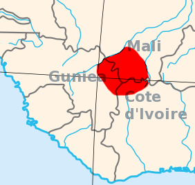
English: I created this, using the Gimp, and a blank area map from Wikpedia Commons, 2007-07-23.
Area map of the Wassoulou (Wassulu, Wassalou, Ouassalou) region of Mali, Guinea (Guinee), Cote d'Ivoire: West Africa. |
| Data | 23 de juliol de 2007 (original upload date) |
| Font | Transferred from en.wikipedia to Commons. |
| Autor | T L Miles de la Viquipèdia en anglès |
Llicència
| S'ha alliberat aquesta obra al domini públic pel seu autor T L Miles de la Viquipèdia en anglès. Això s'aplica a tot el món. En alguns països això pot no ser legalment possible, en tal cas: T L Miles concedeix a tothom el dret d'usar aquesta obra per a qualsevol propòsit, sense cap condició llevat d'aquelles requerides per la llei. |
Registre original de càrregues
La pàgina de descripció original era aquí. Els noms d'usuari a continuació es refereixen a en.wikipedia.
- 2007-07-23 16:56 T L Miles 282×267×8 (34707 bytes) I created this, using the Gimp, and a blank area map from Wikpedia Commons, 2007-07-23. Area map of the Wassoulou (Wassulu, Wassalou, Ouassalou) region of Mali, Guinea (Guinee), Cote d'Ivoire: West Africa.
Historial del fitxer
Cliqueu una data/hora per veure el fitxer tal com era aleshores.
| Data/hora | Miniatura | Dimensions | Usuari/a | Comentari | |
|---|---|---|---|---|---|
| actual | 15:14, 12 gen 2008 | | 282 × 267 (34 Ko) | File Upload Bot (Magnus Manske) | {{BotMoveToCommons|en.wikipedia}} {{Information |Description={{en|I created this, using the Gimp, and a blank area map from Wikpedia Commons, 2007-07-23. Area map of the Wassoulou (Wassulu, Wassalou, Ouassalou) region of Mali, Guinea (Guinee), Cote d'Iv |
Ús del fitxer
La pàgina següent utilitza aquest fitxer:
Ús global del fitxer
Utilització d'aquest fitxer en altres wikis:
- Utilització a cs.wikipedia.org
- Utilització a en.wikipedia.org
- Utilització a fi.wikipedia.org
- Utilització a fr.wikipedia.org
- Utilització a kcg.wikipedia.org
- Utilització a lt.wikipedia.org
- Utilització a nl.wikipedia.org
- Utilització a nqo.wikipedia.org
- Utilització a pt.wikipedia.org
- Utilització a sv.wikipedia.org
- Utilització a sw.wikipedia.org
- Utilització a uk.wikipedia.org
- Utilització a www.wikidata.org