Fitxer:Wearmouth Bridge to the Sea 2nd March 1967.jpg
Fitxer original (1.021 × 853 píxels, mida del fitxer: 195 Ko, tipus MIME: image/jpeg)
| Aquest fitxer i la informació mostrada a continuació provenen del dipòsit multimèdia lliure Wikimedia Commons. |
Resum
| Descripció |
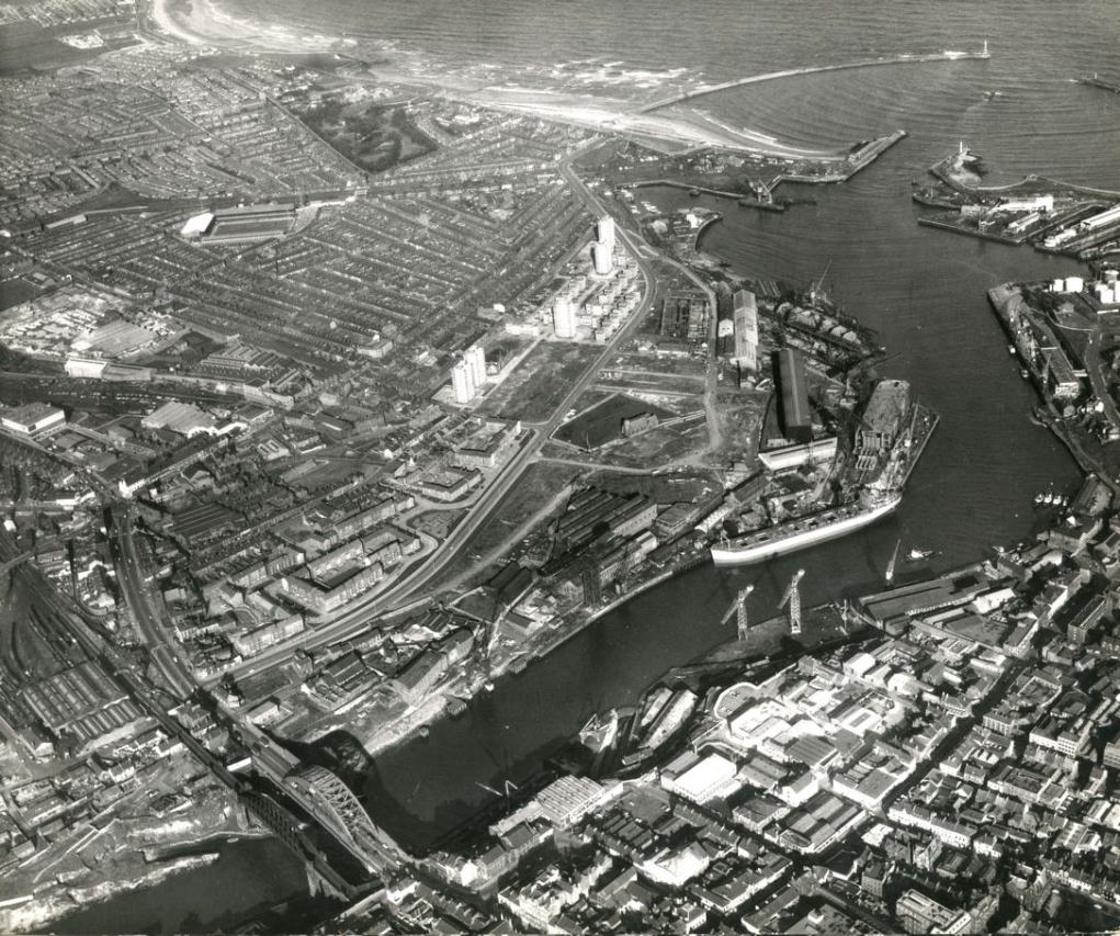
With Roker pier top right, this photograph looks north over Monkwearmouth and Roker. You can pick out Roker Park football ground top left and J.L. Thompson & Sons outfitting yard, centre right, working on a cargo vessel. Reference: TWAS: DT.TUR.7.7 (Copyright) We're happy for you to share this digital image within the spirit of The Commons. Please cite 'Tyne & Wear Archives & Museums' when reusing. Certain restrictions on high quality reproductions and commercial use of the original physical version apply though; if you're unsure please email archives@twmuseums.org.uk. To purchase a hi-res copy please email archives@twmuseums.org.uk quoting the title and reference number |
| Data | |
| Font |
Wearmouth Bridge to the Sea 2nd March 1967
|
| Autor | TWAM - Tyne & Wear Archives & Museums |
| Permís (Com reutilitzar aquest fitxer) |
TWAM - Tyne & Wear Archives & Museums @ Flickr Commons |
| Posició de la càmera | | Aquesta i altres imatges properes a: OpenStreetMap |
|---|
Llicència
This image was taken from Flickr's The Commons. The uploading organization may have various reasons for determining that no known copyright restrictions exist, such as:
More information can be found at https://flickr.com/commons/usage/. Please add additional copyright tags to this image if more specific information about copyright status can be determined. See Commons:Licensing for more information. |
| Aquesta imatge, originalment publicada a Flickr, ha estat verificada el July 6, 2011 per l'administrador o usuari acreditat File Upload Bot (Magnus Manske), i ha confirmat que en aquella data estava disponible a Flickr sota la llicència indicada. |
Historial del fitxer
Cliqueu una data/hora per veure el fitxer tal com era aleshores.
| Data/hora | Miniatura | Dimensions | Usuari/a | Comentari | |
|---|---|---|---|---|---|
| actual | 13:55, 6 jul 2011 | | 1.021 × 853 (195 Ko) | File Upload Bot (Magnus Manske) | {{Information |Description=With Roker pier top right, this photograph looks north over Monkwearmouth and Roker. You can pick out Roker Park football ground top left and J.L. Thompson & Sons outfitting yard, centre right, working on a cargo vessel. Refere |
Ús del fitxer
La pàgina següent utilitza aquest fitxer:
Ús global del fitxer
Utilització d'aquest fitxer en altres wikis:
- Utilització a en.wikipedia.org
- Utilització a fr.wikipedia.org