Fitxer:Yakehashiri lava flow Aerial photograph A.jpg

Mida d'aquesta previsualització: 800 × 561 píxels. Altres resolucions: 320 × 224 píxels | 640 × 449 píxels | 1.024 × 718 píxels | 1.280 × 898 píxels | 2.637 × 1.850 píxels.
Fitxer original (2.637 × 1.850 píxels, mida del fitxer: 1,75 Mo, tipus MIME: image/jpeg)
| Aquest fitxer i la informació mostrada a continuació provenen del dipòsit multimèdia lliure Wikimedia Commons. |
Resum
| Descripció |
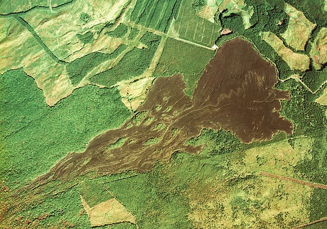
English: Yakehashiri lava flow Aerial photograph A. Kipukas surrounded by lava flows from Iwate volcano, Japan. (Move the mouse pointer over the image to see them.)
日本語: 岩手山の焼走り熔岩流周辺の空中写真。cto-76-4_c7_23を利用 |
| Data | |
| Font | 国土情報ウェブマッピングシステム |
| Autor | 国土交通省 |
| Posició de l'objecte | | Aquesta i altres imatges properes a: OpenStreetMap |
|---|
Llicència

|
El titular dels drets d'autor d'aquest arxiu, the Ministry of Land, Infrastructure, Transport and Tourism of Japan, permet que qualsevol pugui usar-lo per a qualsevol propòsit, sempre que el titular dels drets d'autor sigui reconegut correctament. La redistribució, les obres derivades, l'ús comercial, i qualsevol altre ús està permès. |
Reconeixement:
Copyright © National Land Image Information (Color Aerial Photographs), Ministry of Land, Infrastructure, Transport and Tourism
|
 |
This image is copyrighted by the Ministry of Land, Infrastructure, Transport and Tourism of Japan. For terms of use, see the stipulation to use of National Land Information (in Japanese) and message from MLIT (in Japanese and English). When you display this image on an article, include the following phrase in the description: "Made based on National Land Image Information (Color Aerial Photographs), Ministry of Land, Infrastructure, Transport and Tourism".
|
| Anotacions | Aquesta imatge té anotacions: Vegeu-les a Commons |
Historial del fitxer
Cliqueu una data/hora per veure el fitxer tal com era aleshores.
| Data/hora | Miniatura | Dimensions | Usuari/a | Comentari | |
|---|---|---|---|---|---|
| actual | 08:34, 11 juny 2012 | | 2.637 × 1.850 (1,75 Mo) | さかおり | {{Information |Description ={{en|1=Yakehashiri lava flow Aerial photograph A}} {{ja|1=焼走り熔岩流付近の空中写真。cto-76-4_c7_23を利用}} |Source =国土情報ウェブマッピングシステム |Author =国土交通... |
Ús del fitxer
La pàgina següent utilitza aquest fitxer:
Ús global del fitxer
Utilització d'aquest fitxer en altres wikis:
- Utilització a en.wikipedia.org
- Utilització a ja.wikipedia.org