Fitxer:Yom Kippur War map-2.png

Mida d'aquesta previsualització: 399 × 600 píxels. Altres resolucions: 159 × 240 píxels | 401 × 603 píxels.
Fitxer original (401 × 603 píxels, mida del fitxer: 65 Ko, tipus MIME: image/png)
| Aquest fitxer i la informació mostrada a continuació provenen del dipòsit multimèdia lliure Wikimedia Commons. |
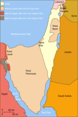
| Descripció | Self-made line drawing of a map Israel's ceasefire lines with its neighboring countries after its establishment (1949), after the Six Day War (June 1967) and the last front line after Yom Kippur War (late October 1973). After the latter. Author: User:Raul654 Source of line drawing: Now-deleted image Image:Jom kippur war.jpg, which was originally uploaded to the polish Wikipedia at http://pl.wikipedia.org/wiki/Grafika:Jom_kippur_war.jpg -- Ministerstwo Spraw Zagranicznych Izraela, za zgodÄ… Ambasady Izraela w Polsce. -- Ministry of Foreign Affairs of Israel, with the permission of Israel Embassy in Poland |
| Data | (UTC) |
| Font | |
| Autor |
|
| Això és una imatge retocada, cosa que vol dir que ha estat alterada digitalment de la seva versió original. Modificacions: Israeli territory before the Six day war is the same as after. L'original es pot veure a: Yom Kippur War map.svg:
|
Jo, el titular dels drets d'autor d'aquest treball, el public sota la següent llicència:
Aquest fitxer està publicat sota la llicència de Creative Commons Reconeixement i Compartir Igual 2.5 Genèrica.
- Sou lliure de:
- compartir – copiar, distribuir i comunicar públicament l'obra
- adaptar – fer-ne obres derivades
- Amb les condicions següents:
- reconeixement – Heu de donar la informació adequada sobre l'autor, proporcionar un enllaç a la llicència i indicar si s'han realitzat canvis. Podeu fer-ho amb qualsevol mitjà raonable, però de cap manera no suggereixi que l'autor us dóna suport o aprova l'ús que en feu.
- compartir igual – Si modifiqueu, transformeu, o generareu amb el material, haureu de distribuir les vostres contribucions sota una llicència similar o una de compatible com l'original
Registre original de càrregues
This image is a derivative work of the following images:
- File:Yom_Kippur_War_map.svg licensed with Cc-by-sa-2.5
- 2010-07-03T14:35:39Z ChrisO 400x602 (44519 Bytes)
- 2010-02-20T12:52:00Z Hohum 400x602 (44263 Bytes) Added border lines.
- 2009-05-31T13:42:58Z Hohum 400x602 (46716 Bytes) Fixed Golan Heights colour.
- 2009-05-31T13:39:18Z Hohum 400x602 (46739 Bytes) Adjusted colours to be less garish, more map-like.
- 2009-04-09T11:32:56Z Kordas 400x602 (46093 Bytes) colours fixed
- 2008-05-15T23:23:08Z Kordas 400x602 (46918 Bytes) Updated version (Added "West Bank" and seas names' in white)
- 2007-10-03T04:11:40Z Andrew Hampe 400x602 (47298 Bytes) Removed line referencing external jpeg image.
- 2007-10-03T03:58:34Z Raul654 400x602 (46347 Bytes) Standard svg
- 2007-10-03T03:55:12Z Raul654 400x602 (46347 Bytes) Self-made line drawing of a map of Israel's territories before and after the Yom Kippur War. Source of line drawing: Now-deleted image [[:Image:Jom kippur war.jpg]] {{cc-by-sa}}
Uploaded with derivativeFX
Historial del fitxer
Cliqueu una data/hora per veure el fitxer tal com era aleshores.
| Data/hora | Miniatura | Dimensions | Usuari/a | Comentari | |
|---|---|---|---|---|---|
| actual | 13:03, 2 des 2010 | | 401 × 603 (65 Ko) | Supreme Deliciousness | {{Information |Description=Self-made line drawing of a map of Israel's territories before and after the Yom Kippur War. Author: User:Raul654 Source of line drawing: Now-deleted image Image:Jom kippur war.jpg, which was originally uploaded to the |
Ús del fitxer
Les 6 pàgines següents utilitzen aquest fitxer:
- Guerra del Yom Kippur
- Resolució 446 del Consell de Seguretat de les Nacions Unides
- Resolució 452 del Consell de Seguretat de les Nacions Unides
- Resolució 471 del Consell de Seguretat de les Nacions Unides
- Resolució 605 del Consell de Seguretat de les Nacions Unides
- Resolució 636 del Consell de Seguretat de les Nacions Unides
Ús global del fitxer
Utilització d'aquest fitxer en altres wikis:
- Utilització a da.wikipedia.org
- Utilització a et.wikipedia.org
- Utilització a it.wikipedia.org
- Utilització a it.wikibooks.org
- Utilització a jv.wikipedia.org
- Utilització a nl.wikipedia.org
- Utilització a pt.wikipedia.org
- Utilització a sh.wikipedia.org
- Utilització a vi.wikipedia.org
- Utilització a www.wikidata.org