Fitxer:Aegadian Islands map.png
No hi ha cap versió amb una resolució més gran.
Aegadian_Islands_map.png (690 × 528 píxels, mida del fitxer: 112 Ko, tipus MIME: image/png)
| Aquest fitxer i la informació mostrada a continuació provenen del dipòsit multimèdia lliure Wikimedia Commons. |
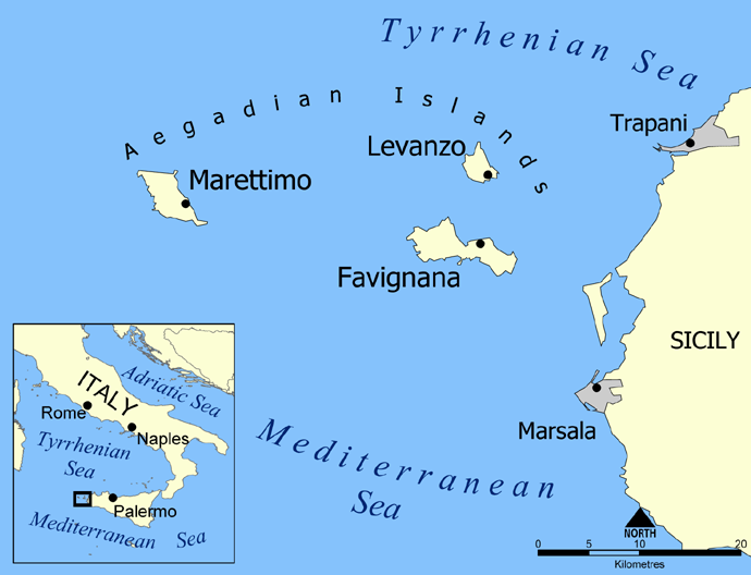
Map of the Aegadian Islands showing the islands of Favignana, Levanzo, and Marettimo, and the nearby port cities of Trapani and Marsala, Sicily.
Blank version available at Image:Aegadian Islands blank map.png.
Created by NormanEinstein, May 19, 2005.
| Jo, el titular del copyright d'aquesta obra, l'allibero al domini públic. Això s'aplica a tot el món. En alguns països això pot no ser legalment possible, en tal cas: Jo faig concessió a tothom del dret d'usar aquesta obra per a qualsevol propòsit, sense cap condició llevat d'aquelles requerides per la llei. |
Historial del fitxer
Cliqueu una data/hora per veure el fitxer tal com era aleshores.
| Data/hora | Miniatura | Dimensions | Usuari/a | Comentari | |
|---|---|---|---|---|---|
| actual | 00:24, 27 feb 2016 | | 690 × 528 (112 Ko) | Ras67 | black frame removed, opt. |
| 15:58, 19 maig 2005 |  | 700 × 538 (150 Ko) | NormanEinstein | Map of the Aegadian Islands showing the islands of Favignana, Levanzo, and Marettimo, and the nearby port cities of Trapani and Marsala, Sicily. Created by NormanEinstein, May 19, 2005. {{PD-self}} |
Ús del fitxer
Les 4 pàgines següents utilitzen aquest fitxer:
Ús global del fitxer
Utilització d'aquest fitxer en altres wikis:
- Utilització a ar.wikipedia.org
- Utilització a be.wikipedia.org
- Utilització a bg.wikipedia.org
- Utilització a bs.wikipedia.org
- Utilització a cs.wikipedia.org
- Utilització a da.wikipedia.org
- Utilització a de.wikipedia.org
- Utilització a el.wikipedia.org
- Utilització a en.wikipedia.org
- Utilització a en.wiktionary.org
- Utilització a eo.wikipedia.org
- Utilització a fa.wikipedia.org
- Utilització a fi.wikipedia.org
- Utilització a fr.wikipedia.org
- Utilització a fr.wiktionary.org
- Utilització a fy.wikipedia.org
- Utilització a gl.wikipedia.org
- Utilització a he.wikipedia.org
- Utilització a id.wikipedia.org
- Utilització a it.wikipedia.org
- Utilització a ja.wikipedia.org
Vegeu més usos globals d'aquest fitxer.