Fitxer:Italy and Illyria 1084 AD.svg

Mida d'aquesta previsualització PNG del fitxer SVG: 478 × 600 píxels. Altres resolucions: 191 × 240 píxels | 383 × 480 píxels | 612 × 768 píxels | 816 × 1.024 píxels | 1.633 × 2.048 píxels | 586 × 735 píxels.
Fitxer original (fitxer SVG, nominalment 586 × 735 píxels, mida del fitxer: 522 Ko)
| Aquest fitxer i la informació mostrada a continuació provenen del dipòsit multimèdia lliure Wikimedia Commons. |

Resum
| Descripció |
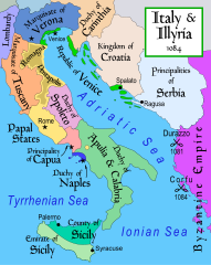
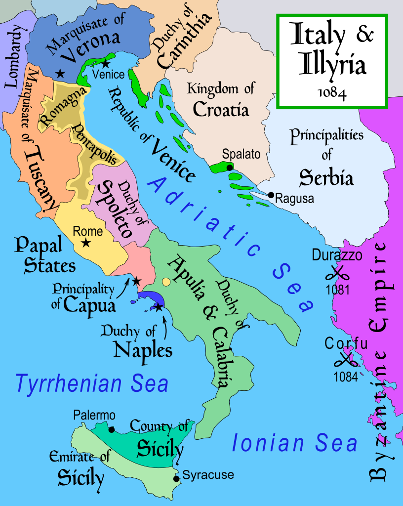
English: Map of Italy and the Illyrian coast in the year 1084.
Part of a series of maps on the history of Italy:
|
| Data | |
| Font | Treball propi |
| Autor | MapMaster |
| Altres versions |
[]
|
| SVG genesis | Aquesta imatge vectorial ha estat creada amb Inkscape. |


References
- This map from Allyn & Bacon, Longman, textbook publishers.
- Bjorklund, Oddvar; Holmboe, Haakon; Rohr, Anders (1970) Historical Atlas of the World, Barnes & Noble, NY, SBN: 389-00253-4.
- Hammond Atlas Corporation (2007) Hammond Historical World Atlas.
- Matthew, Donald (1989) Atlas of Medieval Europe, Time-Life Books.
- This map of 1000 AD Italy from Fordham University, adapted from Muir's Historical Atlas, (1911).
- This map of 1050 AD Italy, from the 1923 The Historical Atlas by William R. Shepherd
- This Wikipedia map of the w:en:Holy Roman Empire
- Šišić, Ferdo (1990) Povijest Hrvata u vrijeme narodnih vladara & the Baška tablet (to denote the territorial integrity of Croatia; islands, coastal borders etc.)
Llicència
Jo, el titular dels drets d'autor d'aquest treball, el public sota la següent llicència:
Aquest fitxer està publicat sota la llicència de Creative Commons Reconeixement i Compartir Igual 2.5 Genèrica.
- Sou lliure de:
- compartir – copiar, distribuir i comunicar públicament l'obra
- adaptar – fer-ne obres derivades
- Amb les condicions següents:
- reconeixement – Heu de donar la informació adequada sobre l'autor, proporcionar un enllaç a la llicència i indicar si s'han realitzat canvis. Podeu fer-ho amb qualsevol mitjà raonable, però de cap manera no suggereixi que l'autor us dóna suport o aprova l'ús que en feu.
- compartir igual – Si modifiqueu, transformeu, o generareu amb el material, haureu de distribuir les vostres contribucions sota una llicència similar o una de compatible com l'original
derivative works
Derivative works of this file: Italy and Illyria 1084 v2-ar.svg
Historial del fitxer
Cliqueu una data/hora per veure el fitxer tal com era aleshores.
| Data/hora | Miniatura | Dimensions | Usuari/a | Comentari | |
|---|---|---|---|---|---|
| actual | 21:19, 22 oct 2017 | | 586 × 735 (522 Ko) | Ras67 | frame removed |
| 14:16, 23 nov 2011 |  | 588 × 735 (644 Ko) | Kathovo | Reverted to version as of 12:20, 29 July 2007 not an svg | |
| 20:06, 23 gen 2011 |  | 480 × 600 (224 Ko) | Er-vet-en | whoops, sorry for this | |
| 20:04, 23 gen 2011 |  | 480 × 600 (224 Ko) | Er-vet-en | resize | |
| 19:50, 23 gen 2011 |  | 744 × 1.052 (224 Ko) | Er-vet-en | plit and some islands are are actually in Croatia's dominion from about 1076 (since the previous map relied on maps from earlier) This is proven by the acclaimed historian Ferdo Šišić, and the culturally significant Bashka tablet (which proved that ki | |
| 14:20, 29 jul 2007 |  | 588 × 735 (644 Ko) | Lokal Profil | Cleaned up code (specifically loads of empty groups) | |
| 07:43, 15 abr 2007 |  | 588 × 735 (695 Ko) | MapMaster | Minor changes | |
| 05:56, 13 feb 2007 |  | 588 × 735 (694 Ko) | MapMaster | Map of Italy and the Illyrian coast in the year 1084 |
Ús del fitxer
Les 2 pàgines següents utilitzen aquest fitxer:
Ús global del fitxer
Utilització d'aquest fitxer en altres wikis:
- Utilització a ar.wikipedia.org
- Utilització a azb.wikipedia.org
- Utilització a bg.wikipedia.org
- Utilització a bn.wikipedia.org
- Utilització a bs.wikipedia.org
- Utilització a cs.wikipedia.org
- Utilització a da.wikipedia.org
- Utilització a de.wikipedia.org
- Utilització a el.wikipedia.org
- Utilització a en.wikipedia.org
- Utilització a et.wikipedia.org
Vegeu més usos globals d'aquest fitxer.