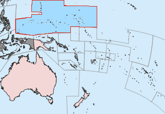
Fitxer:TTPI-locatormap.png
TTPI-locatormap.png (326 × 225 píxels, mida del fitxer: 11 Ko, tipus MIME: image/png)
Historial del fitxer
Cliqueu una data/hora per veure el fitxer tal com era aleshores.
| Data/hora | Miniatura | Dimensions | Usuari/a | Comentari | |
|---|---|---|---|---|---|
| actual | 03:27, 17 juny 2010 |  | 326 × 225 (11 Ko) | Ras67 | cropped |
| 16:52, 19 nov 2006 |  | 330 × 228 (14 Ko) | Electionworld | == Summary == This is a locator map of the former Trust Territory of the Pacific Islands (TTPI). The map is based off of a locator map of Palau found on the German Wiki at de:Bild:Palau-Pos.png; it was created by German Wiki user [[:de:Benutzer:T |
Ús del fitxer
Les 3 pàgines següents utilitzen aquest fitxer:
Ús global del fitxer
Utilització d'aquest fitxer en altres wikis:
- Utilització a ar.wikipedia.org
- Utilització a ast.wikipedia.org
- Utilització a azb.wikipedia.org
- Utilització a az.wikipedia.org
- Utilització a be.wikipedia.org
- Utilització a bg.wikipedia.org
- Utilització a cs.wikipedia.org
- Utilització a da.wikipedia.org
- Utilització a de.wikipedia.org
- Utilització a en.wikipedia.org
- Trust Territory of the Pacific Islands
- Decolonization
- Japan–Oceania relations
- List of national border changes (1914–present)
- Aftermath of World War II
- High Commissioner of the Trust Territory of the Pacific Islands
- Wikipedia:Graphics Lab/Map workshop/Archive/Oct 2010
- Wikipedia:Reference desk/Archives/Humanities/2020 June 23
- Utilització a eo.wikipedia.org
- Utilització a es.wikipedia.org
- Utilització a fa.wikipedia.org
- Utilització a fi.wikipedia.org
- Utilització a fr.wikipedia.org
- Utilització a he.wikipedia.org
- Utilització a hu.wikipedia.org
- Utilització a hy.wikipedia.org
- Utilització a ia.wikipedia.org
- Utilització a id.wikipedia.org
- Utilització a it.wikipedia.org
- Utilització a ja.wikipedia.org
- Utilització a ko.wikipedia.org
- Utilització a lt.wikipedia.org
- Utilització a mr.wikipedia.org
- Utilització a nl.wikipedia.org
Vegeu més usos globals d'aquest fitxer.


